–
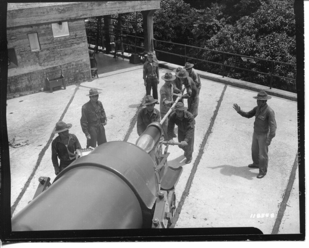
Zd102. Flickr 001. SC 118548 Men of Battery “E” 91st C.A. loading 10 Inch shells, this image was received from the Phil. Dept. 11 Jan. 1941. This must be Battery Grubbs, and Philippine Scouts in Fort Mills on Corregidor Island in Manila Bay. Another 10 Inch battery was in Fort Wint, on Grande Island in Subic Bay.
———————————————
Friends from the Coastal Defense Study Group (cdsg.org) have given me many high-resolution pictures from NARA and other sources. I will share them here. It will be a slow project, will do it, only, when I have some time. This is the first post in this new subgroup.
These pictures are also uploaded into my Flickr account, in HIGH RESOLUTION, follow the download steps in this Flickr album, click here:
———————————————
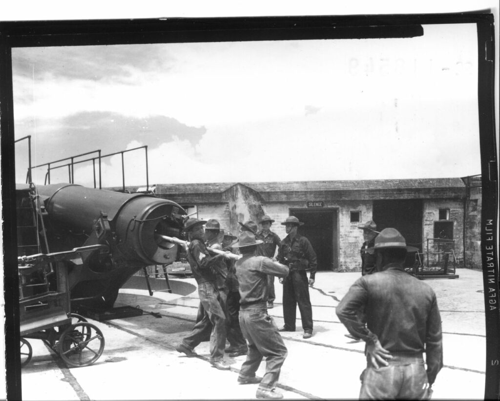
Zd103. Flickr 002. SC 118549 Men of Battery “E” 91st C.A. loading 10 Inch shells, this image was received from the Phil. Dept. 11 Jan. 1941. This must be Battery Grubbs and Philippine Scouts in Fort Mills on Corregidor Island in Manila Bay. Another 10 Inch battery was in Fort Wint, on Grande Island in Subic Bay.
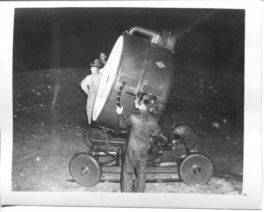
Zd104. Flickr 003. Searchlight from Battery “A” 60th C.A in Fort Mills on Corregidor Island in Manila Bay. This image was received from the Phil. Dept. 11 Jan. 1941.
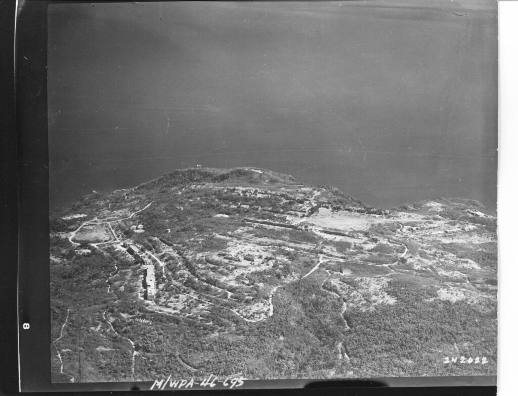
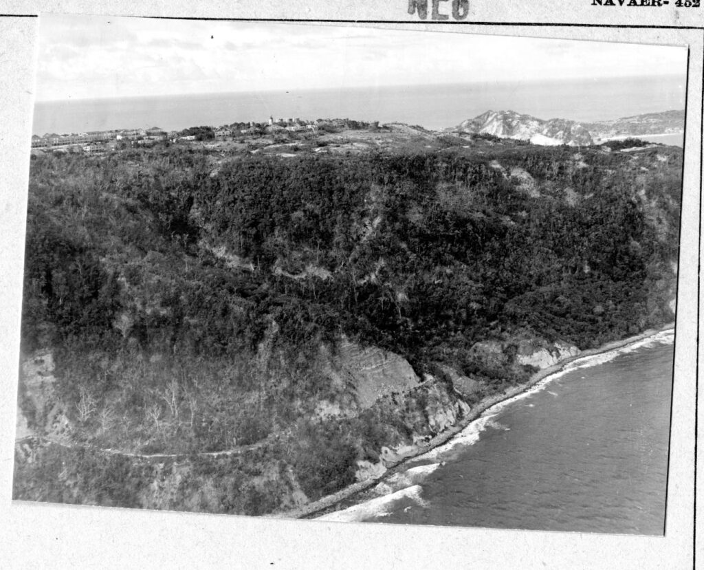
Zd105. Flickr 004. 242022. Aerial view of the former Fort Mills on Corregidor Island in Manila Bay. This is, perhaps, a post WWII image and on back of the picture, it says: released 6/21/46.
Zd106. Flickr 005. SWPA-Sig C-45-13271. 6th Mach 1945. View of Malinta Hill, looking east from Ordonnance Maintenance Shop Topside in Fort Mills on Corregidor Island in Manila Bay. Photographer T/5 Kingsley Fall. From Karl, I’m not sure whether the photographer got his location right! But I can’t make out the exact position either, your comments?
Zd107. Flickr 006. SC 271153. This is obvious the Fort Mills coal fired powerplant, replaced by a separate Diesel Power Plant, standing next, left to it and in the picture! But it is now referred to as the Cold Storage and Ice Plant. T/5 Kingsley Fall was the photographer in Mach 1945 on Corregidor Island in Manila Bay. He took the shot from the Stockade Level, in back of the picture he typed prison.
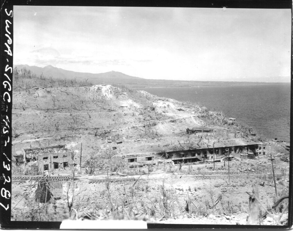
Zd108. Flickr 007. SWPA-Sig C-45-13285. 6th Mach 1945. T/5 Kingsley Fall was the photographer and said the view is of the ruins of San Jose Barrio in Fort Mills, Corregidor Island from Malinta Hill toward Topside.
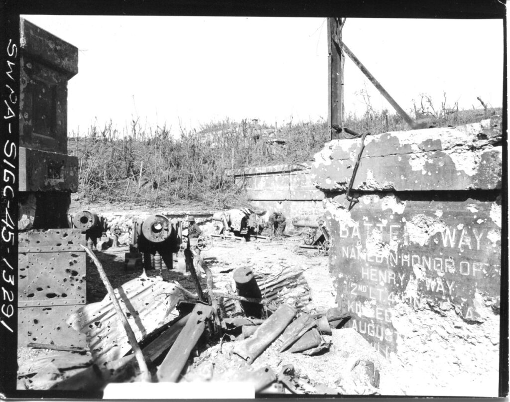
Zd109. Flickr 008. SWPA-Sig C-45-13291. 6th Mach 1945; SC271167. T/5 Kingsley Fall was the photographer and wrote: Damaged 12 Inch Mortars, Battery Way, ex Fort Mills, Corregidor Island P.I.
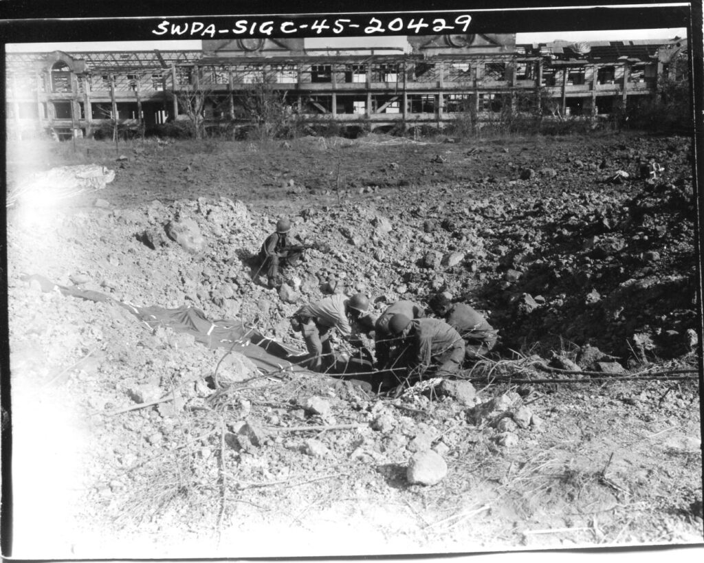
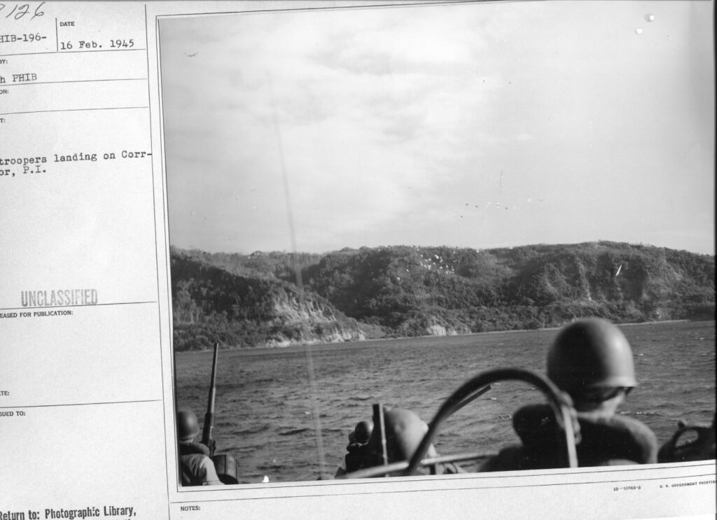
Zd110. Flickr 009. SWPA-Sig C-45-20429. 17th Feb. 1945. Paratroopers of the 462nd Airborne Artillery recover 75mm ammunition which was dropped by chute and landed in a shell crater at Topside in Fort Mills on Corregidor Island in Manila Bay. Photographer Pfc W. Goen.
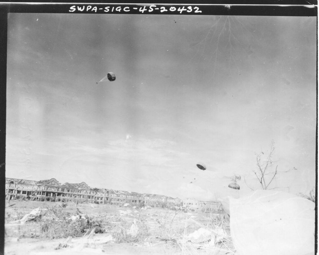
Zd111. Flickr 010. SWPA-Sig C-45-20532. SC-263691. 17th Feb. 1945. C-47s are flying over the “Rock”, (at former Ft. Mills, Corregidor Island, P.I.) and drop supplies, food and water for the men of the 503rd Parachute Inf. Reg’t. who jumped the day before. Photographer: Pfc. W. Goen.
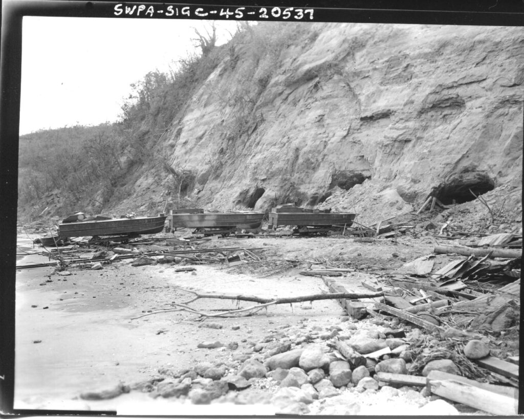
Zd112. Flickr 011. SWPA-Sig C-45-20537. SC-263697. 27th Feb. 1945. Jap. “Q” boats, based on Corregidor Island, P.I. (were manned by suicide volunteers called “Tojo Men” who drove these boats) are brought out on tracks to the ocean. Photographer: T/5 G. Arend. Note: Now we know these are the suicide boat tunnels at the former Fort Mills Officer Beach, north shore, Tailend on Corregidor.
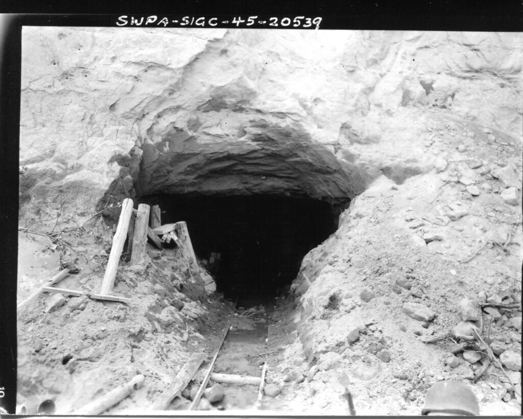
Zd113. Flickr 012. SWPA-Sig C-45-20539. SC-263698. 27th Feb. 1945. Jap. “Q” boats, based on Corregidor Island, P.I. (were manned by suicide volunteers called “Tojo Men” who drove these boats) are brought out on tracks to the ocean. Photographer: T/5 G. Arend. Note: Now we know these are the suicide boat tunnels at the former Fort Mills Officer Beach, north shore, Tailend on Corregidor.
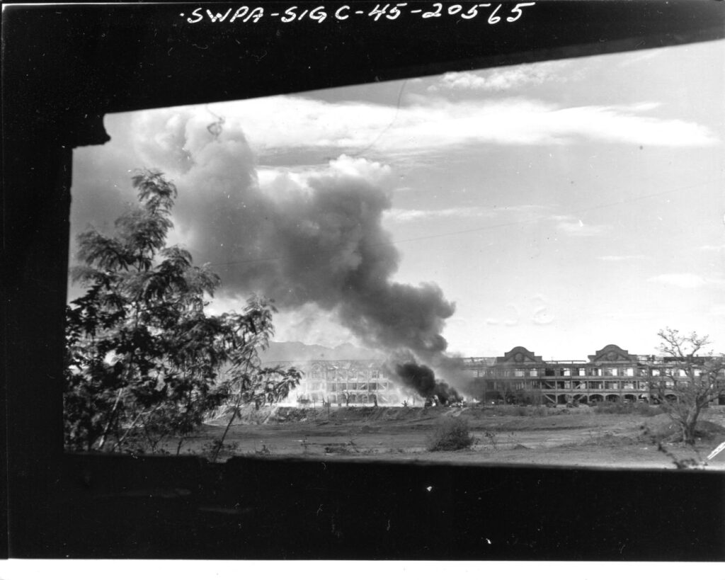
Zd114. Flickr 013. SWPA-Sig C-45-20565. 6th March. 1945; SC-263702. Burning ammunition dump at the 503rd RCT CP on Corregidor Island. Fire was caused by a mysterious explosion which subsequential destroyed the entire dump as well as that section of the building directly behind it. Photographer T/4 Ernani D’Emedio. Note: of course, we know now, this is the so called “Mile Long Barracks” Topside, Fort Mills on Corregidor.
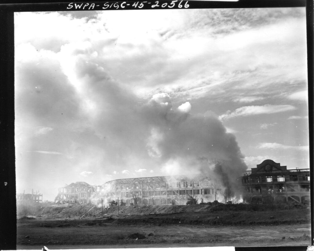
Zd115. Flickr 014. SWPA-Sig C-45-20566. 6th March. 1945; SC-263703. Burning ammunition dump at the 503rd RCT CP on Corregidor Island. Fire was caused by a mysterious explosion which subsequential destroyed the entire dump as well as that section of the building directly behind it. Photographer T/4 Ernani D’Emedio. Note: of course, we know now, this is the so called “Mile Long Barracks” Topside, Fort Mills on Corregidor.
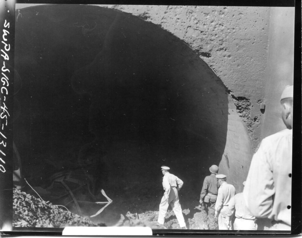
Zd116. Flickr 015. SWPA-Sig C-45-13110. SC-271117. 2nd March. General Douglas MacArthur on tour of inspection in Fort Mills, Corregidor Island, P.I., inspecting the Malinta Tunnel. Before his inspection tour Gen. MacArthur and his staff were present during the raising of the American Flag over the Island. Photographer: T/5 Kingsley Fall. Note: this is the East Entrance of the Malinta Tunnel.
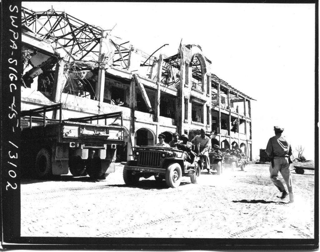
Zd117. Flickr 016. SWPA-Sig C-45-13102. SC-271143. 2nd March. Seated in front of the jeep General Douglas MacArthur, and members of his staff in the following jeeps, start out on an inspection tour in Fort Mills, Corregidor Island P. I. On this day the day the American flag was raised again on the island. Photographer: T/5 G. Arend. Note: of course, we know now, this is in front of the so called “Mile Long Barracks” Topside, Fort Mills on Corregidor.
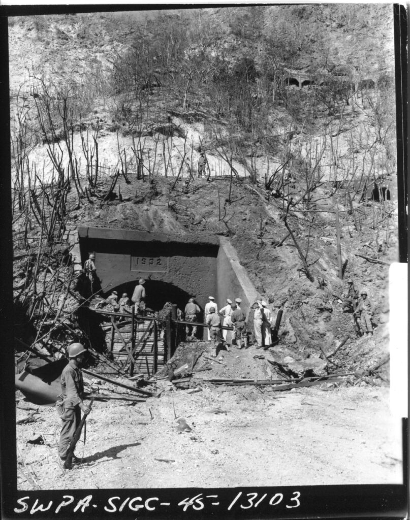
Zd118. Flickr 017. SWPA-Sig C-45-13103. SC-271149. 2nd March. General Douglas MacArthur on tour of inspection in Fort Mills, Corregidor Island, P.I., inspecting the Malinta Tunnel. Before his inspection tour Gen. MacArthur and his staff were present during the raising of the American Flag over the Island. Photographer: T/5 Kingsley Fall. Note: this is the East Entrance of the Malinta Tunnel.
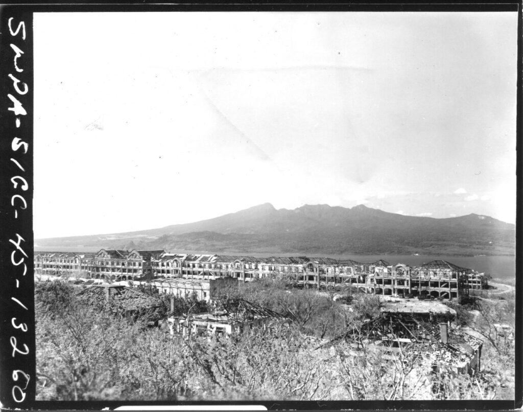
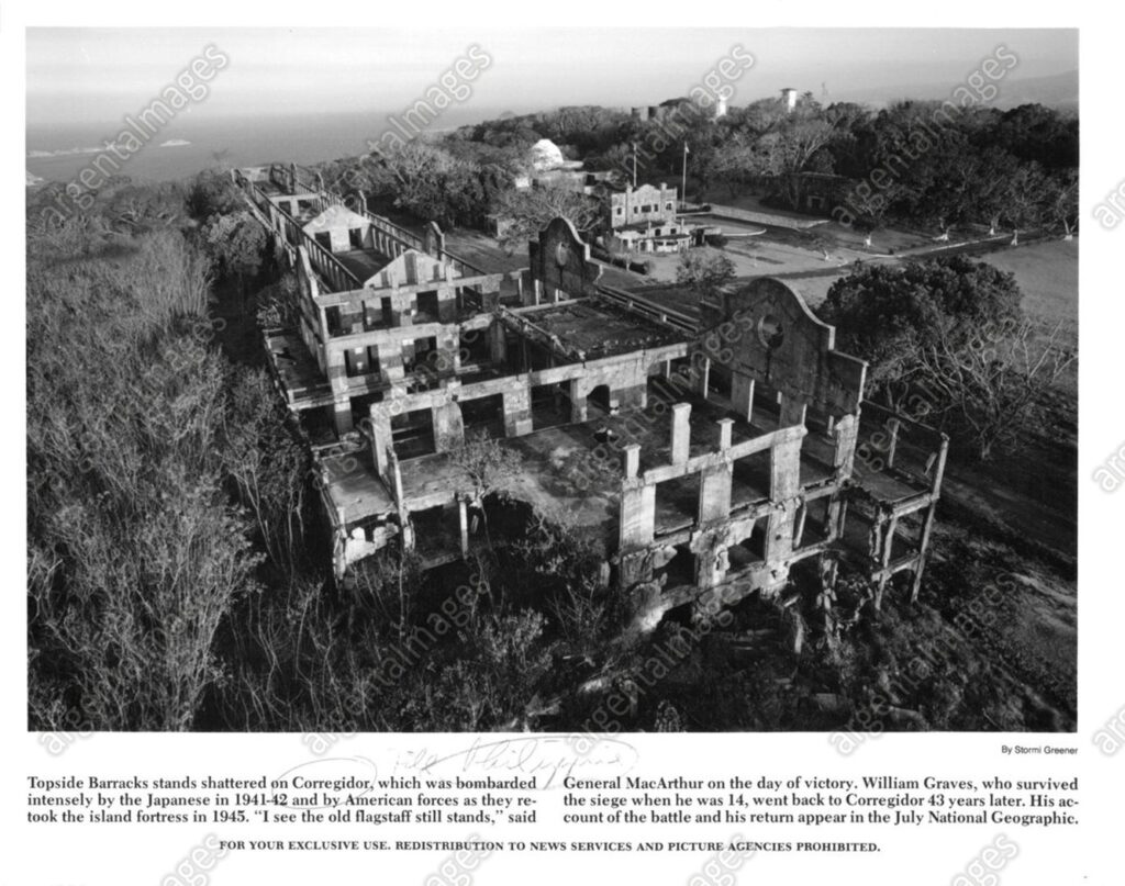
Zd119. Flickr 018. SWPA-Sig C-45-13260. 6th March. 1945; SC-271157. Topside Barracks from the Lighthouse on Corregidor Island, Manila Bay. Photographer: T/5 Kingsley Fall
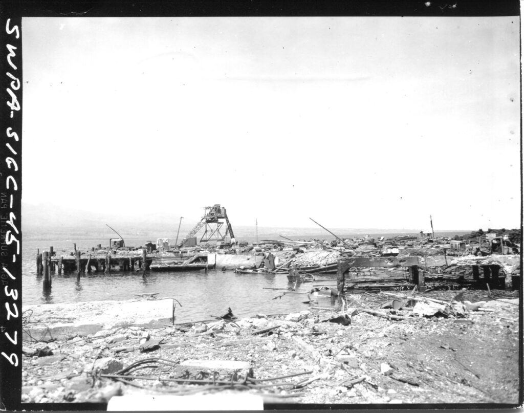
Zd120. Flickr 019. SWPA-Sig C-45-13279. 6th March. 1945; SC-271163. View of wreckage strewn around the North Dock, Corregidor Island, P.I. Photographer: T/5 Kingsley Fall
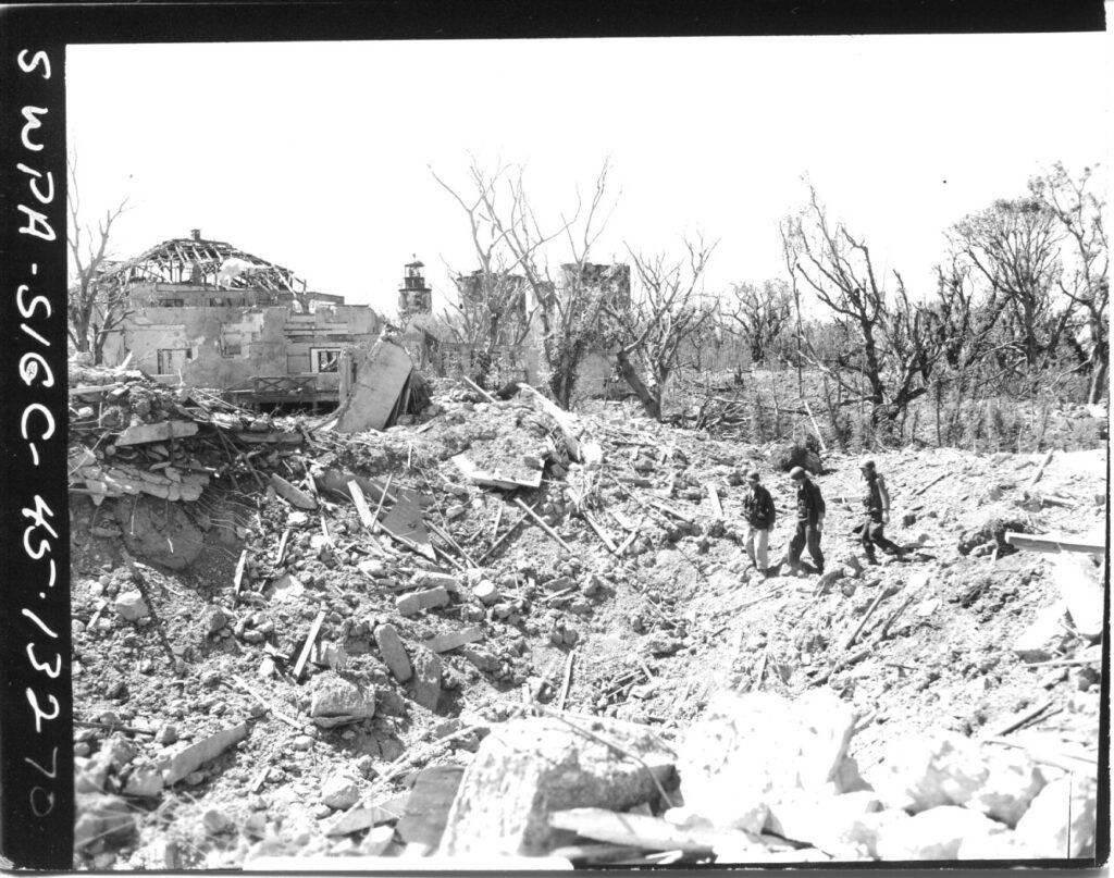
Zd121. Flickr 020. SWPA-Sig C-45-13270. SC-271169. Soldiers make their way on top of mountainous rubble heap of the bombed area surrounding the wreckage of Topside Officer’s Quarters. Photographer: T/5 Kingsley Fall. Note: This seems to be the last east Senor Officer Quarters which was totally destroyed.
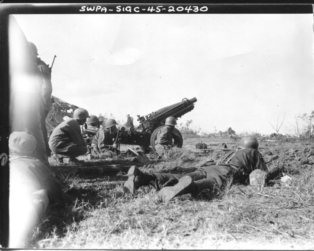
Zd138. Flickr 021. SWPA-Sig C-45-20430 SC-263672. 17 Feb 1945. The crew of the 75mm howitzer had just completed the assembling of it when they were pinned down by sniper and machine gun fire on Corregidor Island. Photographer Pfc W. Goen.
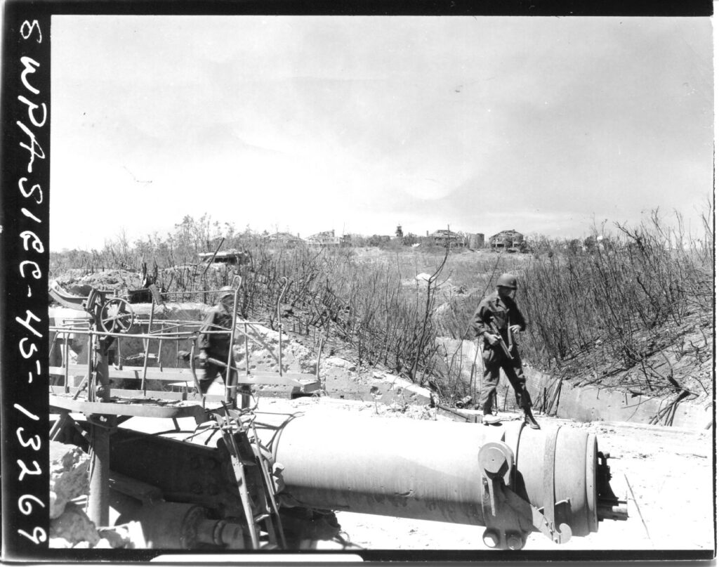
Zd139. Flickr 022. SWPA-Sig C-45-13269. 6th March. 1945; SC-271169.Battery Crockett on Corregidor Island, P.I. Photographer: T/5 Kingsley Fall.
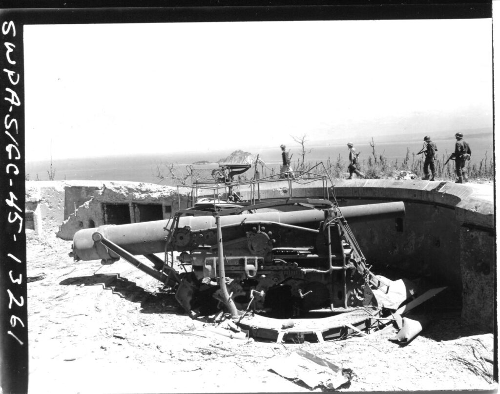
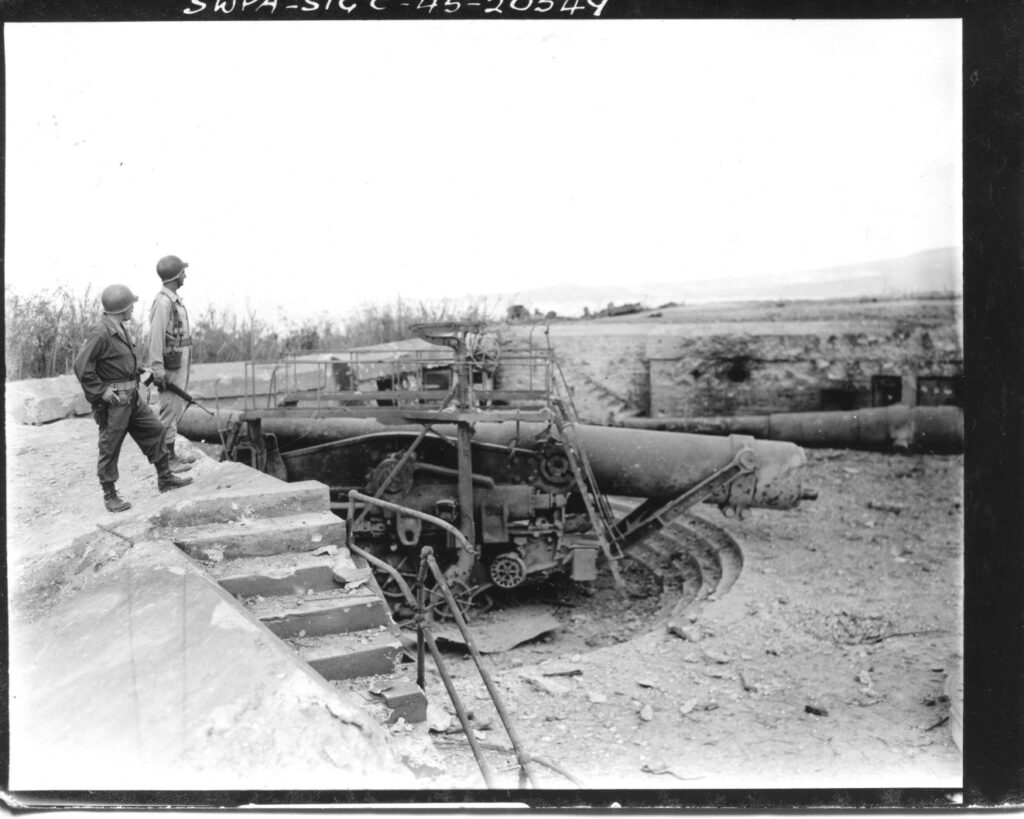
Zd140. Flickr 023. SWPA-Sig C-45-13261. 6th March. 1945; SC-271172. View of 12 Inch disappearing gun at Battery Crockett on Corregidor Island, P.I. Photographer: T/5 Kingsley Fall.
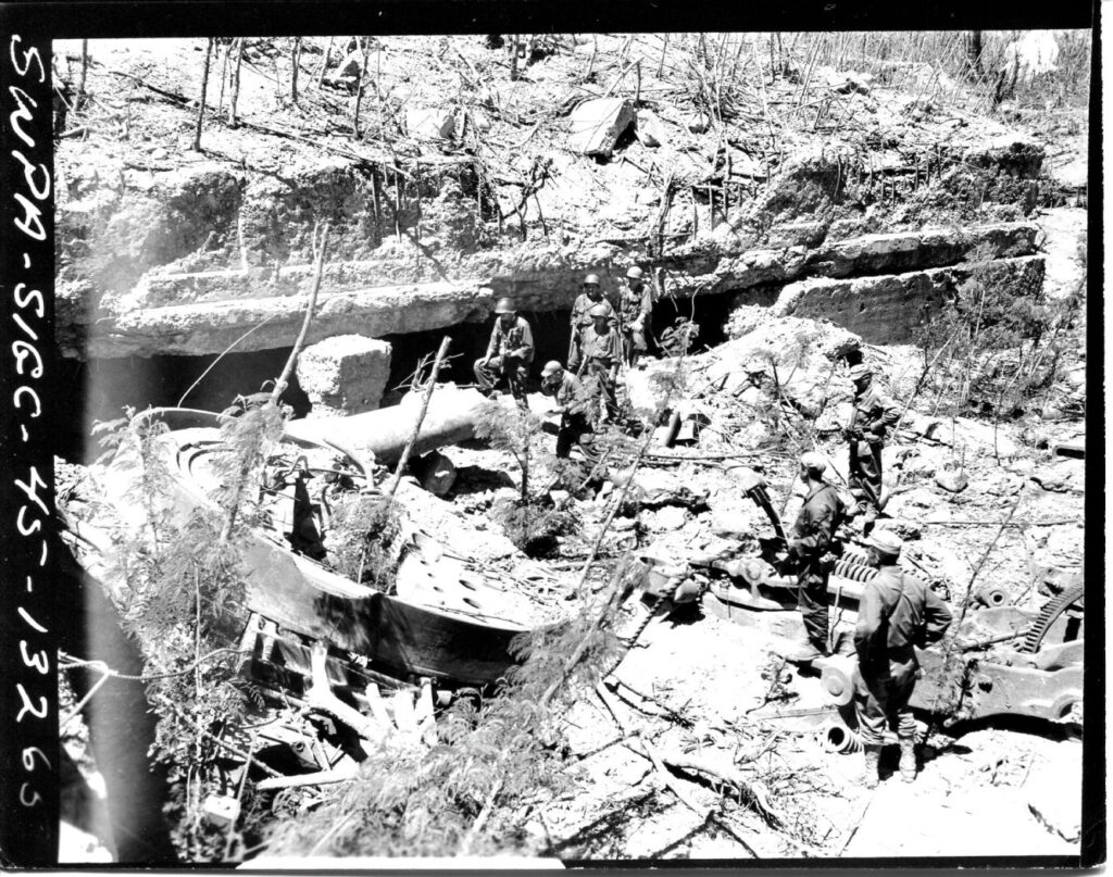
Zd141. Flickr 024. SWPA-Sig C-45-13265. 6th March. 1945; SC-271170. View of Battery Geary on Corregidor Island, P.I. Photographer: T/5 Kingsley Fall
—-7 more images, 28th Sep. 2020
Zd148. Flickr 025. SWPA-Sig C-45-13277, SC-27117. 6th March 1945. Interior view of the newer Diesel Power Plant, Fort Mills on Corregidor Island P.I. Photographer: T/5 Kingsley Fall.
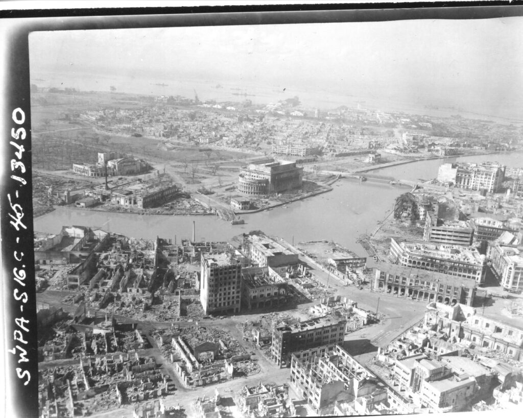
Zd149. Flickr 026. SWPA-Sig C-45-13450. 12th March. 1945. Burned out, battle scarred Manila, see the next image for description-Flickr 027.
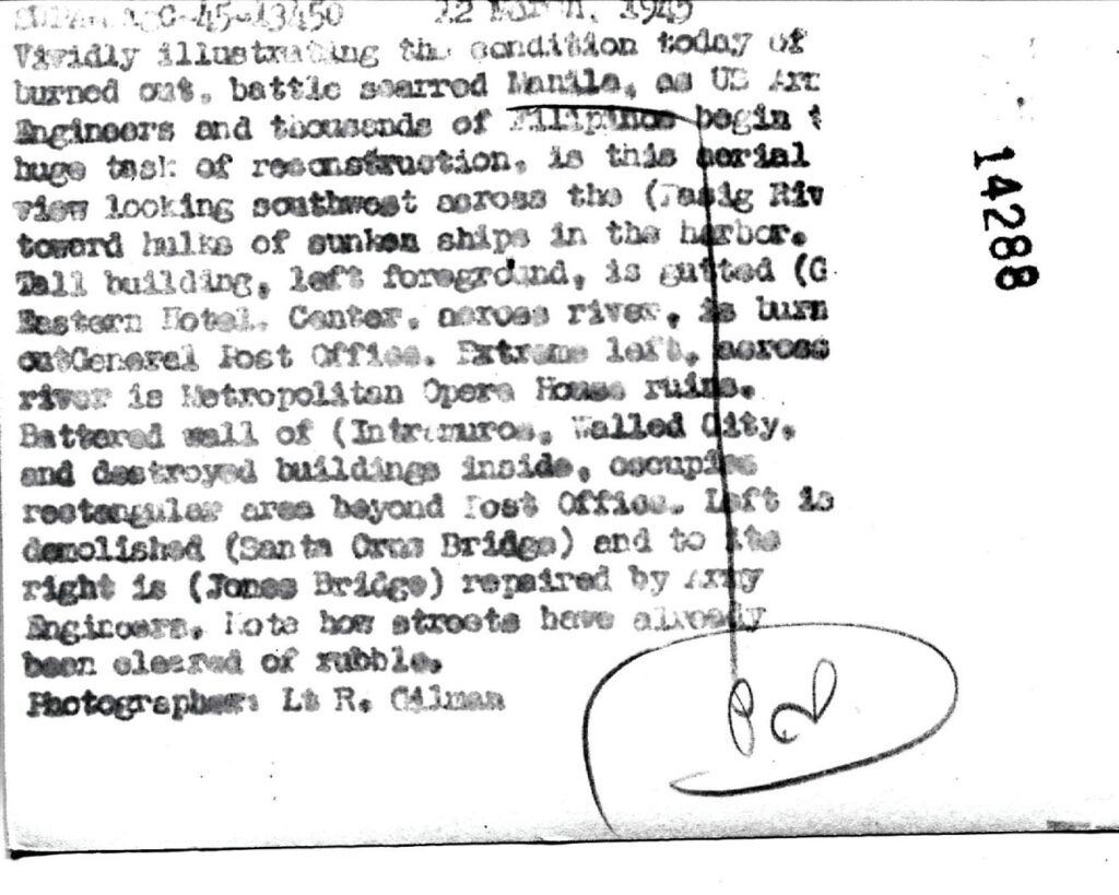
Zd150. Flickr 027. SWPA-Sig C-45-13450. 12th March. 1945. Burned out, battle scarred Manila; this is the description for the previous image # Flickr 026.
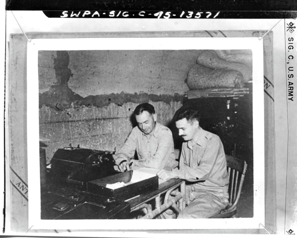
Zd151. Flickr 028. SWPA-Sig C-45-13571. In (maybe April) 1942; SC-264144. Finance Lateral, Malinta Hill Tunnel, on Corregidor Island, P.I. L. to R.: Lt. Col. Roy E. M…fish and Maj. Dwight E. Gard.
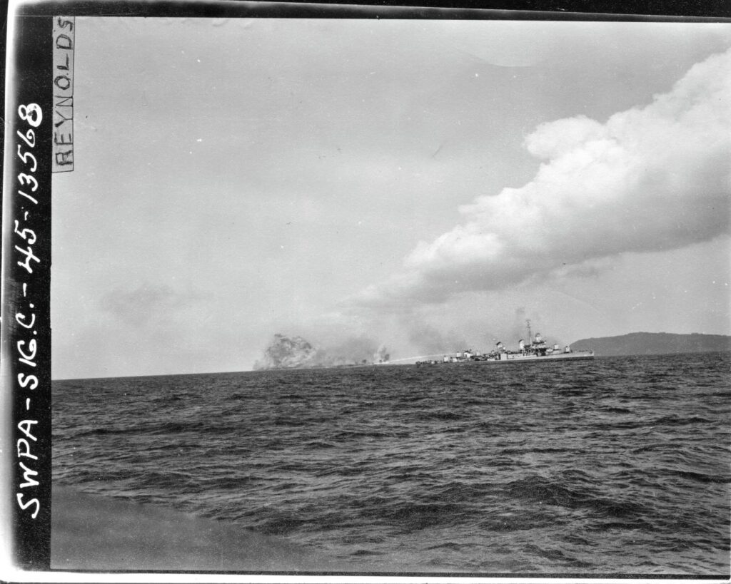
Zd152. Flickr 029. SWPA-Sig C-45-13568 27th March 1945. Naval shelling/bombardment of Caballo Island. The description for this picture is presented in the next image # Flickr 130.
Zd153. Flickr 030. SWPA-Sig C-45-13568 27th March 1945, SC-264142. Naval shelling/bombardment of Caballo Island. This is the description for the previous image # Flickr 129.
Zd154. Flickr 031. Rg111 box 543026. This is a very rare picture of some of the Malinta Hill west side on Corregidor Island showing the Navy Tunnels. It is a captured photo, found in the Japanese side and we can assume it is from 1942. It shows the entrance of three of the Navy 5 tunnel entrances in Malinta Hill. All these three entrances are buried now from landslides. Two more Navy Tunnel entrances are further to the right in a ravine, not too far, and are accessible now; one is difficult to get into now though. I believe we have this picture, or a very similar one, already somewhere in the Corregidor Forum, click here:
But this picture is available now in high resolution in this Flickr album, download it, click here:
WWII, Philippines, from CDSG Friends continues, 30th Sep. 2020; K’s web
Friends from the Coastal Defense Study Group (cdsg.org) have given me many high-resolution pictures from NARA and other sources. I will share them here in high resolution. It will be a slow project, will do it, only when I have some time.
——-7 more images, 30th Sep. 2020. Reminder; these pictures can be downloaded in high resolution at this other album, click here!
Zd165. Flickr 032. SWPA-Sig C-45-13268. This is the destroyed Battery Geary in Fort Mills, on Corregidor Island which was part of the Manila Bay and Harbor Defense Command. I don’t have the official image description. But it is safe to assume that we see Paratroopers from the 503d PIR patrolling thru the battery in Feb. 1945 after they jumped onto Corregidor, to liberate it, on the 16th Feb. 1945. In the distance, left, we see a machinegun Tower, it is located, looking from the photographer’s location, left and east of Battery Crockett.
Zd166. Flickr 033. SWPA-Sig C-45-20549, SC-263699. 26th Feb. 1945. Gen. Marquat and Col. Jones looking over Gun # 2 at Battery Wheeler in Fort Mills on Corregidor Island which was part of the Manila Bay and Harbor Defense Command. In the distance we can see Mariveles on Bataan. The Col. Is carrying a carbine.
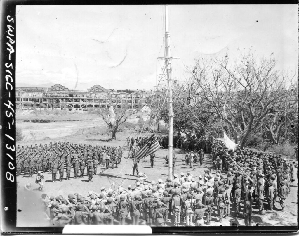
Zd167. Flickr 034. SWPA-Sig C-45-13108. 2nd March. 1945. A historic Day, the Liberators of Corregidor, the 503d PIR and other units of the U.S. Army present the liberated former Ft. Mills to Gen. MacArthur. At this moment the Gen. expresses his gratitude and orders the Flag raised on the Old Flagpole and said: “Don’t let no enemy haul it down”! Gen. MacArthur can be seen directly under the flag. Photographer George Arend
Zd168. Flickr 035. SWPA-Sig C-45-13268. 6th March 1945; SC-271150. West entrance of the Malinta Tunnel on Corregidor Island, P.I. Photographer: T/5 Kingsley Fall.
Zd169. Flickr 036. SWPA-Sig C-45-13262. 6th March 1945. SC-271173. Battery Crockett in Fort Mills on Corregidor Island, P.I. showing the damage to the gun. Photographer: T/5 Kingsley Fall.
Zd170. Flickr 037. SWPA-Sig C-45-13275. 6th March 1945, SC-271174. This is one of 4 anti-air-craft guns of Battery Boston near Battery Wheeler. The description in back of this picture says: Wreckage of gun park, rear of Battery Wheeler, Topside, Corregidor Island, P.I. Photographer: T/5 Kingsley Fall.
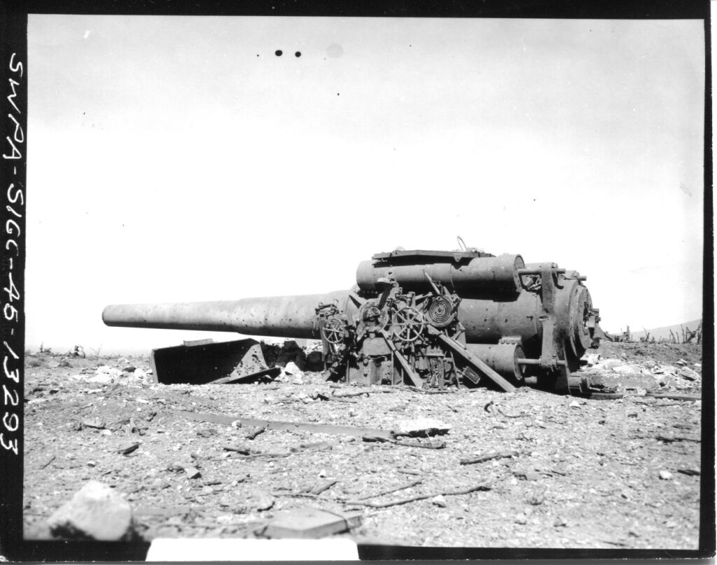
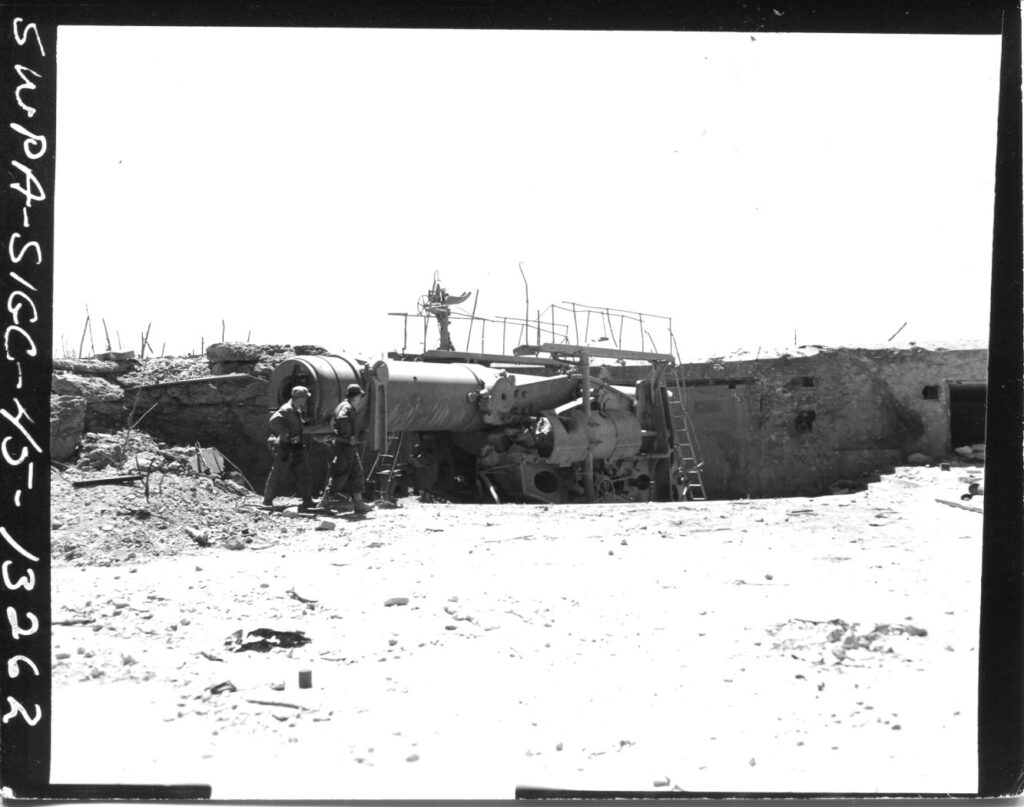
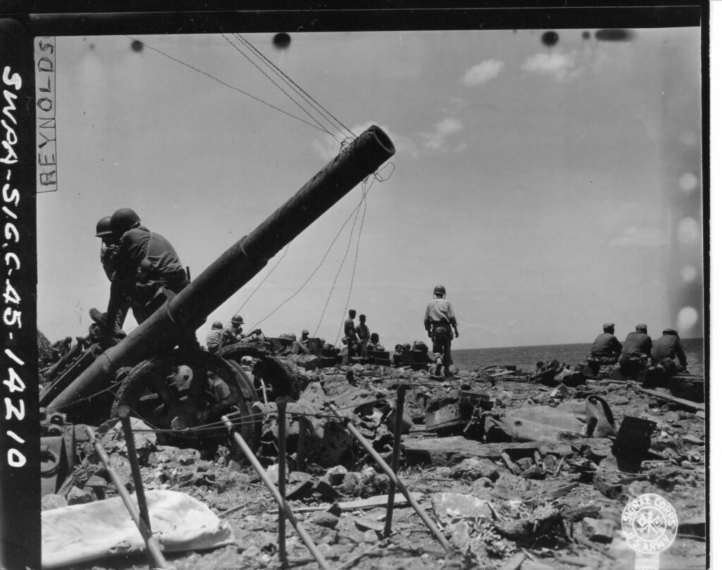
Zd171. Flickr 038. SWPA-Sig C-45-13293. 6th March 1945, SC-271175. The 12 Inch gun of Battery Hearn, Corregidor Island, P.I. SWPA-Sig C-45-13275. 6th March 1945, SC-271174.
——-7 more images, 4th Oct. 2020. Reminder; these pictures can be downloaded in high resolution at this other album, click here!
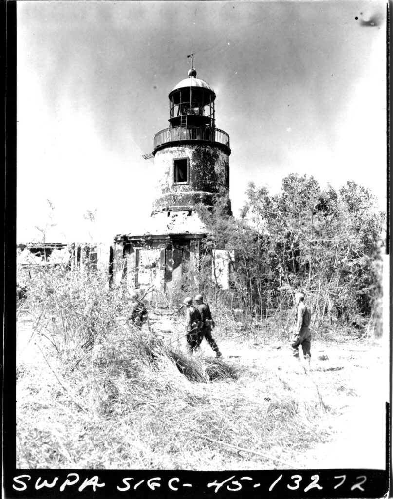
Zd182. Flickr 039. SWPA-Sig C-45-13272 6th March 1945, SC271179. View of the lighthouse on Corregidor Island, P.I. Photographer: T/5 Kingsley Fall.
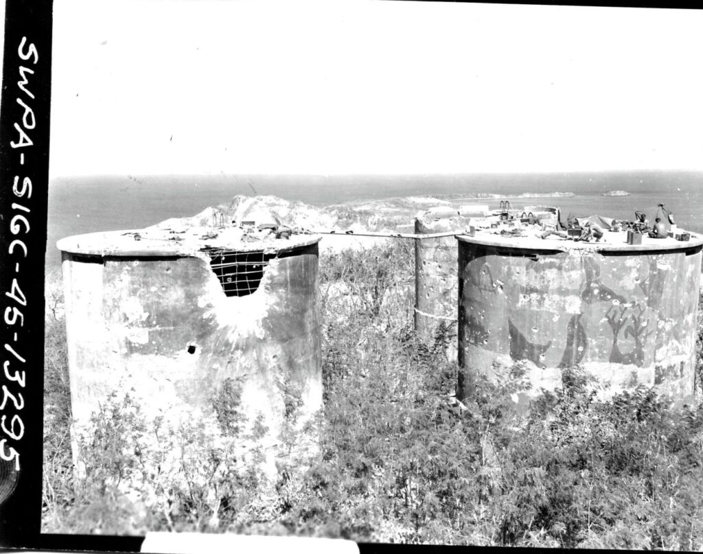
Zd183. Flickr 040. SWPA-Sig C-45-13295 6th March 1945, SC271157. View of the water tanks, Topside on Corregidor Island, P.I. Photographer: T/5 Kingsley Fall.
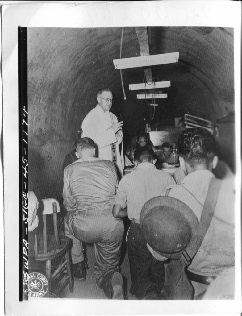
Zd184. Flickr 041. SC 202649 5th March 1942. Catholic Mass being held in Navy Tunnel on Corregidor Island, P.I. Photo by US Army Signal Corps.
Zd185. Flickr 042. This picture has no number, I saw it before in our forum but MAYBE the next picture description (Flickr 043) belongs to this image.
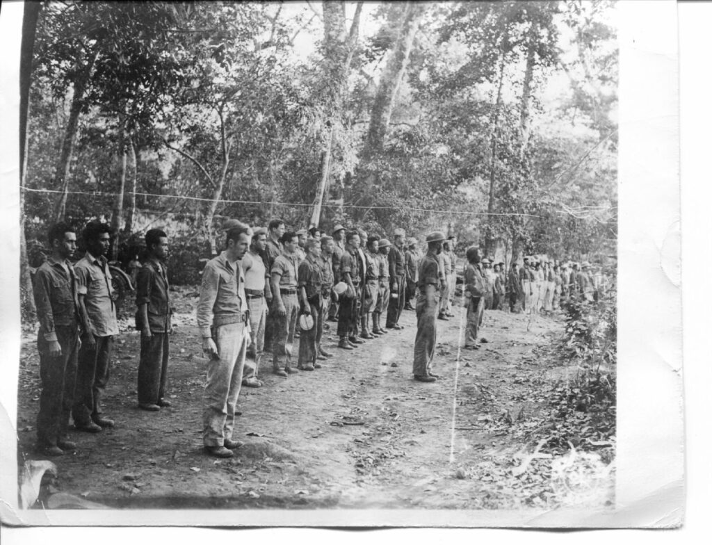
Zd186. Flickr 043. SC 202648. 10 Jan. 1942 Formation at the Signal Corps base camp “Mudhole” on Bataan. Men in the formation are were from the 228th Signal Operation (Sep) and the 252nd Signal Construction P.S. Photo by US Army Signal Corps. Added note from Karl: It also has the words “Prisons Japanese” penciled it. But then the date of Jan. 10th 1942 would not jive with being Japanese prisoners at that date? This description, MAYBE belongs to the previous image # Flickr 042.
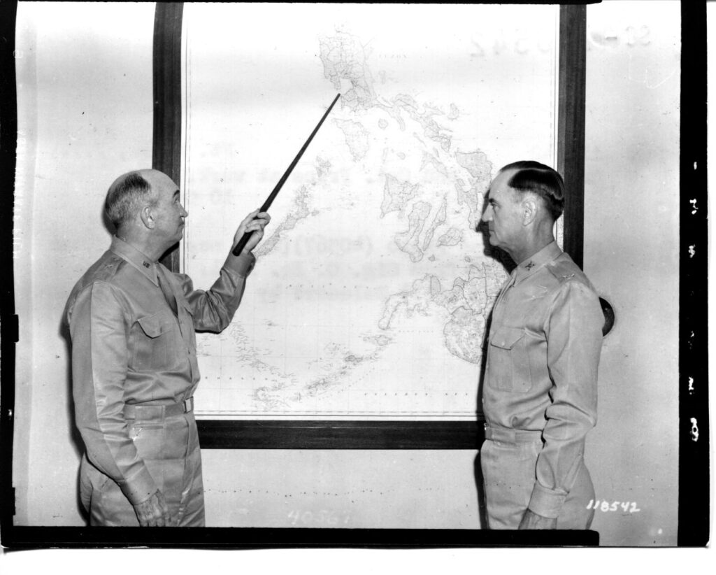
Zd187. Flickr 044. SC-118542. Fort Mills on Corregidor Island the 10th Oct. 1940, Gen. Wilson and Col. Price at work.
Zd188. Flickr 045. SC-118540. Olongapo, P.I. Sept. 1940. Activities of the 24th Field Artillery (P.S.) during target practice. This picture is from my CDSG Friend Karl Wilhelm Schmidt.
Note from Karl: The picture did not have a number but I’m sure the description on another picture jives with the geography. This is what I’m sure of:
The picture is not shot from Ft. Wint which was manned by the Philippine Scouts at that time. It is shot from the area that is Barrio Barretto now (Olongapo City), where I live now, and what used to be the Marine Corps Rifle Range, called Maquinna, the river still has that name. The range was also used for light artillery. The peaks in the distance are from the mountain Cinco Pecos on Redondo Peninsular, separating Subic Bay from the South China Sea. Fort Wint, Grande Island is left and off the picture. I’m 100% sure. This area was turned back to Philippine Authorities, about 1949.
In front, at the beach is what looks like target sleds which perhaps are towed by boats. Targets for the Battleships, Cruisers etc. were bigger and were towed by ships like I served on, ARS, ATA etc.
———————————————–
WWII, Philippines, from CDSG Friends continues, 6th Oct. 2020
Friends from the Coastal Defense Study Group (cdsg.org) have given me many high-resolution pictures from NARA and other sources. I will share them here in high resolution. It will be a slow project, will do it, only when I have some time.
——-7 more images, 30th Sep. 2020. Reminder; these pictures can be downloaded in high resolution at this other album, click here:
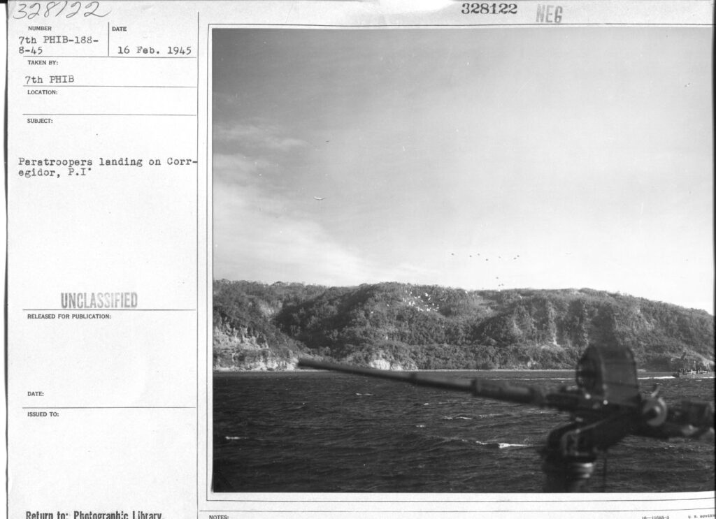
Zd199. Flickr 046. 16th Feb. 1945, 328122. Paratroopers are landing on Corregidor Island, P.I. That is all what the description says. But we Corregidor Friends know what we see. Left is Crockett Ravine. Some paratroopers landed short of their Landing Field “B”, the Fort Mills Golf Course, they landed just under and a little left of Battery Geary. Paratrooper Dick Adams landed there and we showed him around a few years ago. He visited Corregidor again in 2020 for the 75th Anniversary of the Paratrooper assault of Corregidor.
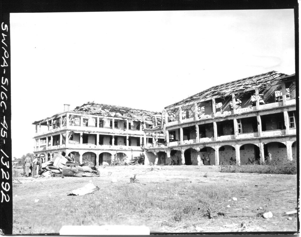
Zd200. Flickr 047. This is the Fort Mills Hospital on Corregidor Island, P.I. We don’t have the description for this image but we Corregidor Friends, know the hospital well. I speculate that the picture was shot on the 6th of March 1945, like many other pictures of this CDSG Collection. This is the rear of the hospital, on the 2nd floor in the left wing, which is between two other wings was the hospital Galley (Kitchen).
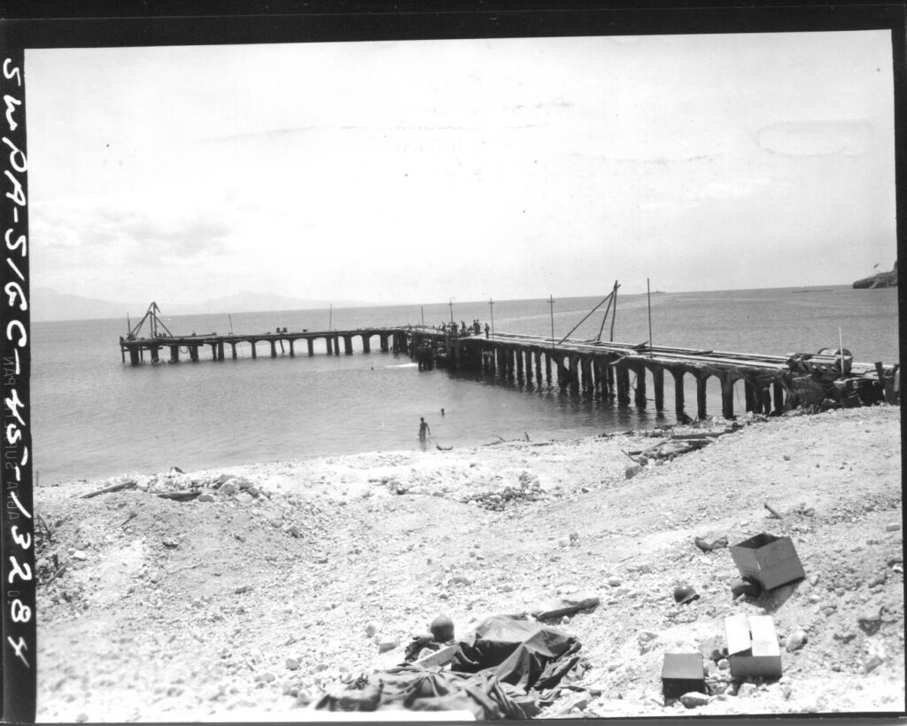
Zd201. Flickr 048. SWPA-Sig C-45-13284. 6th March 1945. South mine dock, south shore Bottomside on Corregidor Island, P.I. Photographer: T/5 Kingsley Fall. During the Siege of Corregidor, it was mainly used by the Navy. Right, we see the Corregidor Breakwater Point and the Army made their amphibious assault, just right of this pier, on the 16th Feb. 1945 and called the landing site: “Black Beach”.
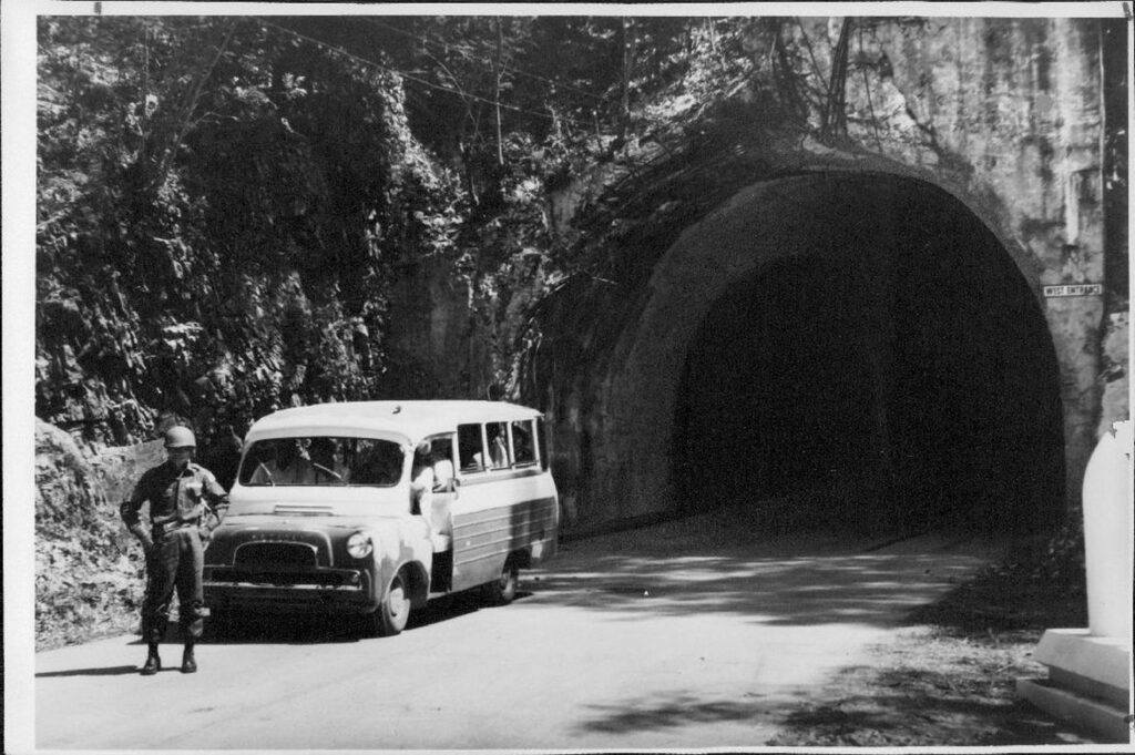
Zd202. Flickr 049. No description for this picture! It seems to be a post WWII image of the west entrance of the famous Malinta Hill Tunnel. The tunnel is cleaned up and the vehicle and the Philippine Soldier are post WWII.
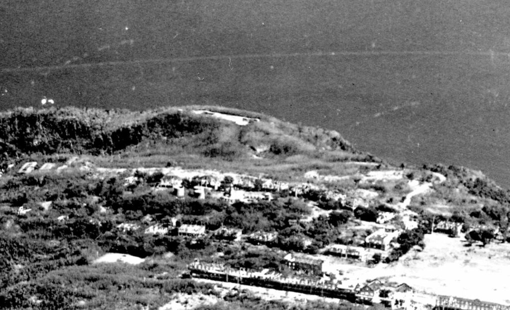
Zd203. Flickr 050. No description for this picture! This aerial shot of Topside, Corregidor Island and is looking south; in front is the so called; “Mile Long Barracks”, the in back is Battery Crockett. It might be a reconnaissance image before the airborne assault in Feb. 1945.
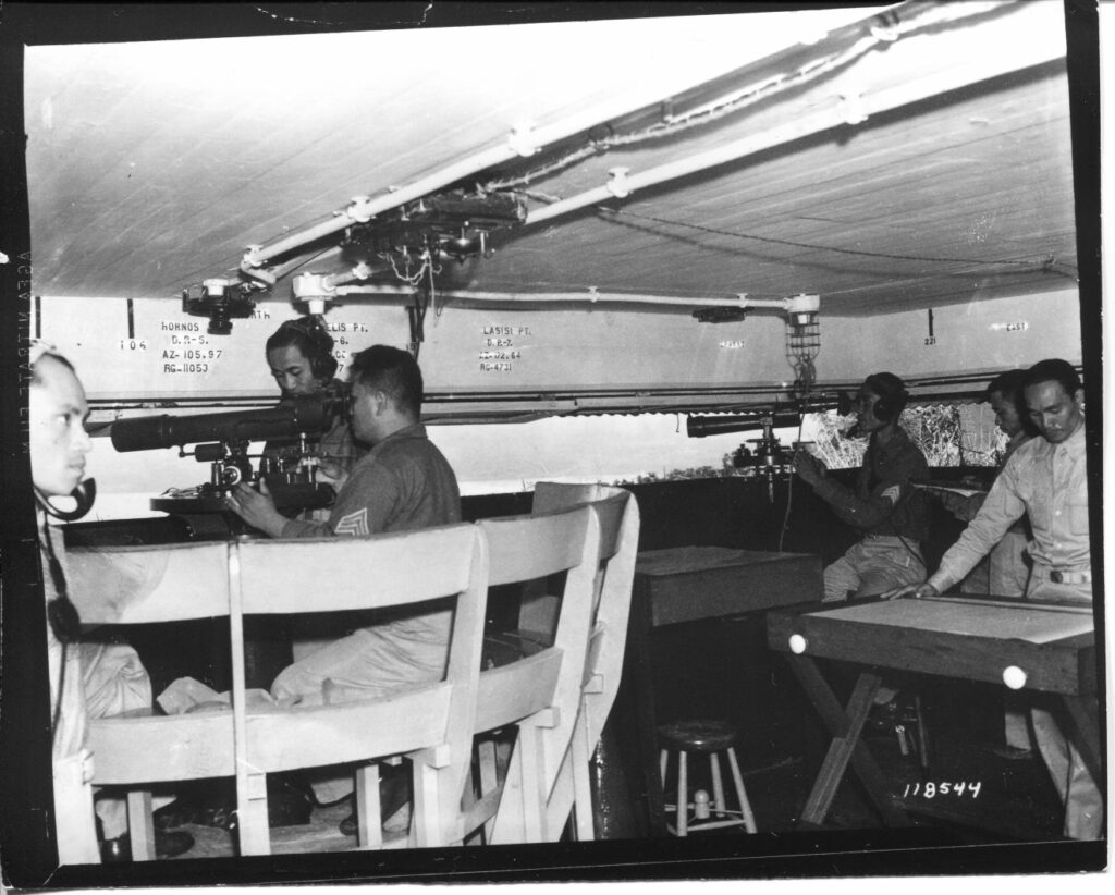
Zd204. Flickr 051. No description for this picture! This is a very unique image, prewar most likely, of a gun control observation post in Fort Mills Coastal Defense Artillery. These are soldiers of the 91st Coast Artillery Regiment, a Coast Artillery Corps regiment in the United States Army, part of the Philippine Scouts. This could be a post for Battery Grubbs or Morrison. The reason we know that, is, the targets listed above the observation slits. Hornos Point is just west of Mariveles. During the siege of Corregidor, it was observed (daytime) that the Japanese Forces were bringing landing boats around that point. The Japanese were immediately targeted and that was the end of daylight trips.
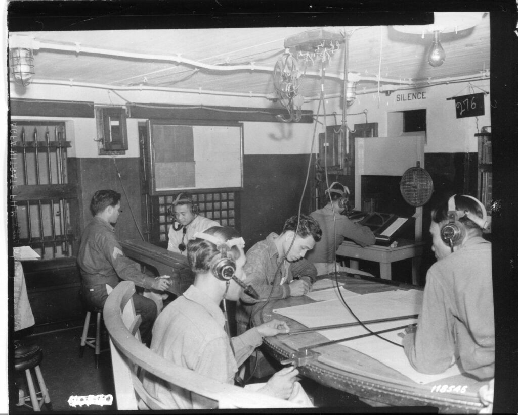
Zd205. Flickr 052. No description for this picture! We can assume this is the plotting room for the previous gun control observation post image in Fort Mills Coastal Defense Artillery. These must be soldiers of the 91st Coast Artillery Regiment, a Coast Artillery Corps regiment in the United States Army, part of the Philippine Scouts. This could be a post for Battery Grubbs or Morrison.
————————–
WWII, Philippines, from CDSG Friends continues, 9th Oct. 2020
Friends from the Coastal Defense Study Group (cdsg.org) have given me many high-resolution pictures from NARA and other sources. I will share them here. It will be a slow project, will do it, only when I have some time.
9 more images. Reminder; these pictures can be downloaded in high resolution at this other album, click here:
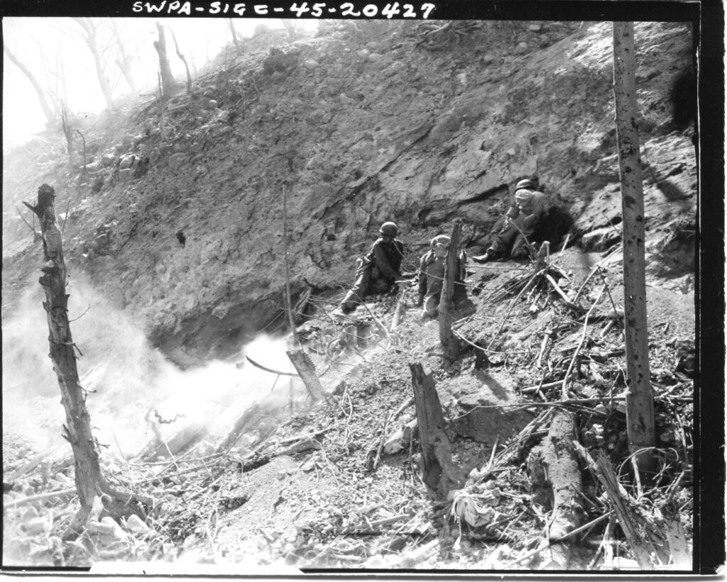
Zd216. Flickr 053. SWPA-Sig C-45-20427. I could find the description for this image but it was in the CDSG folder with all the other images of combat on Corregidor or related events in 1945. I assume this is on Corregidor. It seems, a charge was set off or a grenade were thrown into a tunnel with Japanese soldier occupants.
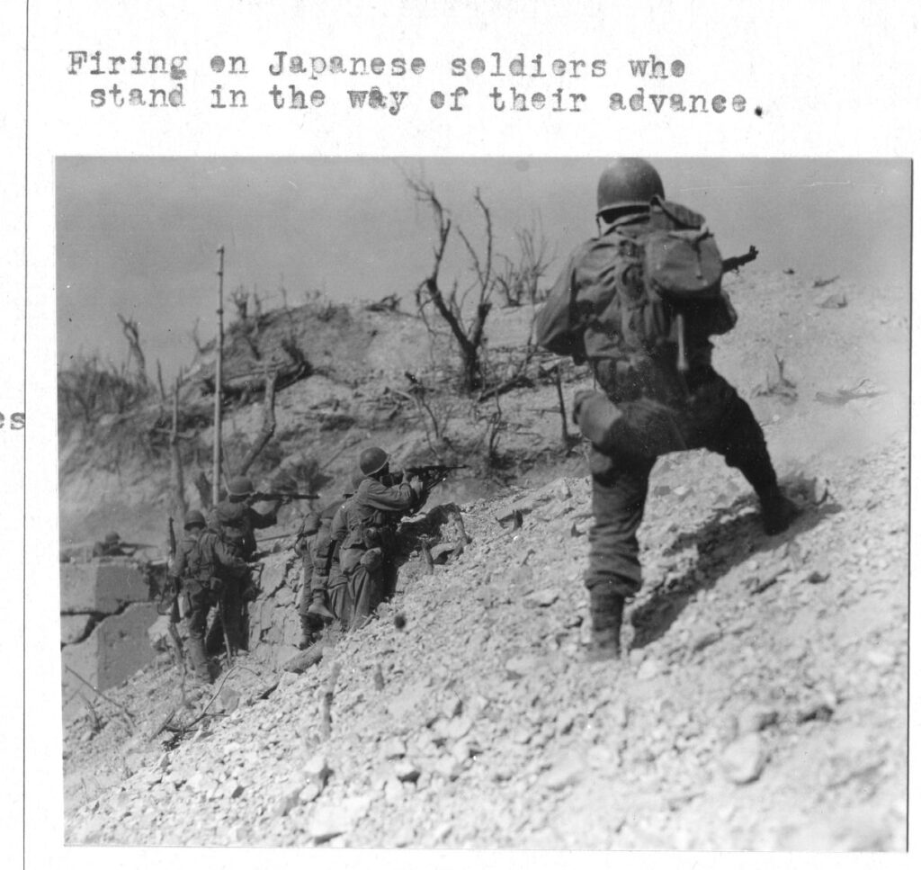
Zd217. Flickr 054. This image has no SWPA-Sig. number nor is the description clear as to where and when of this combat action took place. It was in the CDSG folder with all the other images of combat on Corregidor or related events in 1945. I assume this is on Corregidor.
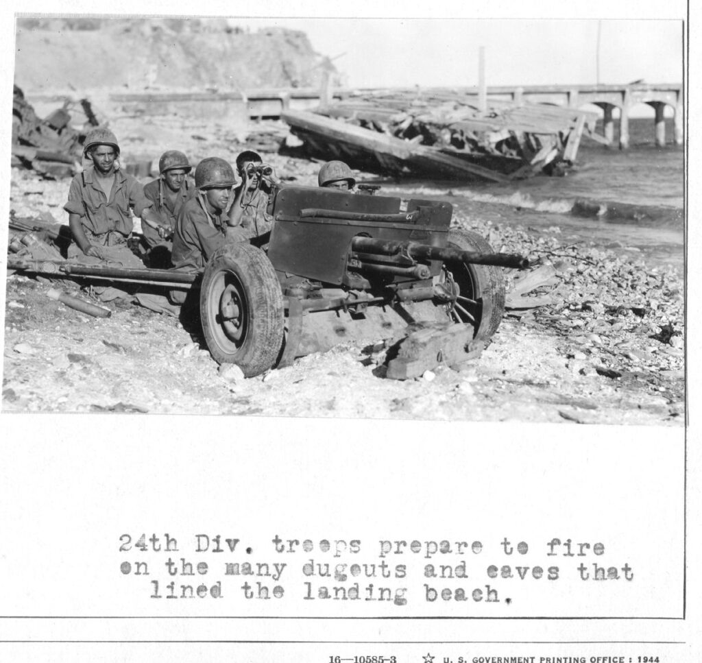
Zd218. Flickr 055. This image has no SWPA-Sig. number nor is the description clear as to where and when of this combat action took place. But I recognize the Fort ills South Mine Dock and better yet, I recognize the San Jose Point, the south end of Malinta Hill on Corregidor. And we the South-Road going around Malinta Hill. The artillery piece is pointing west towards Breakwater Point and the beaches in between.
Zd219. Flickr 056. SWPA-Sig C-45-14767. 24th April 1945. SC263056. This is the Fort Mills Cine, theatre Topside on Corregidor Island, P.I. WE also see the east end of the so-called “Mile Long Barracks”. Photographer T/4 Harry Young.
Zd220. Flickr 057. This image has no SWPA-Sig. number nor a description but it is not needed. This is an aerial shot of Corregidor Island, P.I., perhaps before the 16th Feb. 1945, the day of Liberation for Corregidor. If you zoom in you can recognize all the well-known features of Topside in Fort Mills, The lighthouse, the water tanks, the Mile-Long Barracks etc.
Zd221. Flickr 058. This is unique image of the so-called “Mile-Long-Barracks”, the eastern half of it. It must be shot at 1970 or after, the Dome of the Pacific War Memorial is in sight.
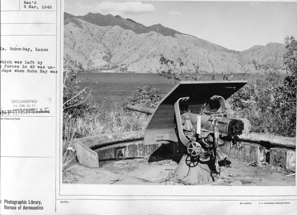
Zd222. Flickr 059. This partial image description is clear about Subic Bay and it indicates the US Forces left this gun there in 1942 and that the Japanese did not use it. The image apparently was shot in 1945. I have been in the former Fort Wint on Grande Island in Subic Bay many times and I’s sure this is one of four 3 Inch guns of Battery Jewell. It is facing Mount Cinco Pecos on the Peninsular that separates Subic Bay from the South China Sea.
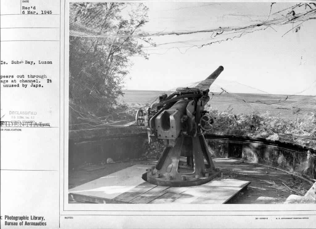
Zd223. Flickr 060. This partial image description is clear about Subic Bay and it indicates the US Forces left this gun there in 1942 and that the Japanese did not use it. The image apparently was shot in 1945. I have been in the former Fort Wint on Grande Island in Subic Bay many times and this gun could be one of several 3 Inch guns of Battery Flake. We see land at left and that should be Bataan.
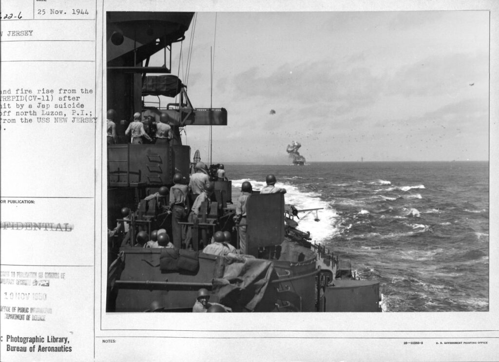
Zd224. Flickr 061. The partial description seems to be talking about the USS Intrepid CV-11 under attack as observed from the USS New Jersey. The following paragraph is copied from Wikipedia: A Japanese air raid on 25 November struck the fleet shortly after noon. Two kamikazes crashed into Intrepid, killing sixty-six men and causing a serious fire. The ship remained on station, however, and the fires were extinguished within two hours. She was detached for repairs the following day, and reached San Francisco on 20 December.
————————–
WWII, Philippines, from CDSG Friends continues, 19th Oct. 2020
Friends from the Coastal Defense Study Group (cdsg.org) have given me many high-resolution pictures from NARA and other sources. I will share them here. It will be a slow project, will do it, only when I have some time.
6 more images. Reminder; these pictures can be downloaded in high resolution at this other album, click here:
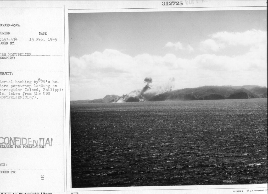
Zd247. Flickr 062. Aerial bombing by B-24s, 15th Feb. 1945, before the paratroop landings 16th Feb. 1945 on Corregidor Islands Philippine Islands (P.I.) Photo taken from the USS Montpelier CL-54. Note from Karl: Those bombs seem to have hit the area of James Ravine.
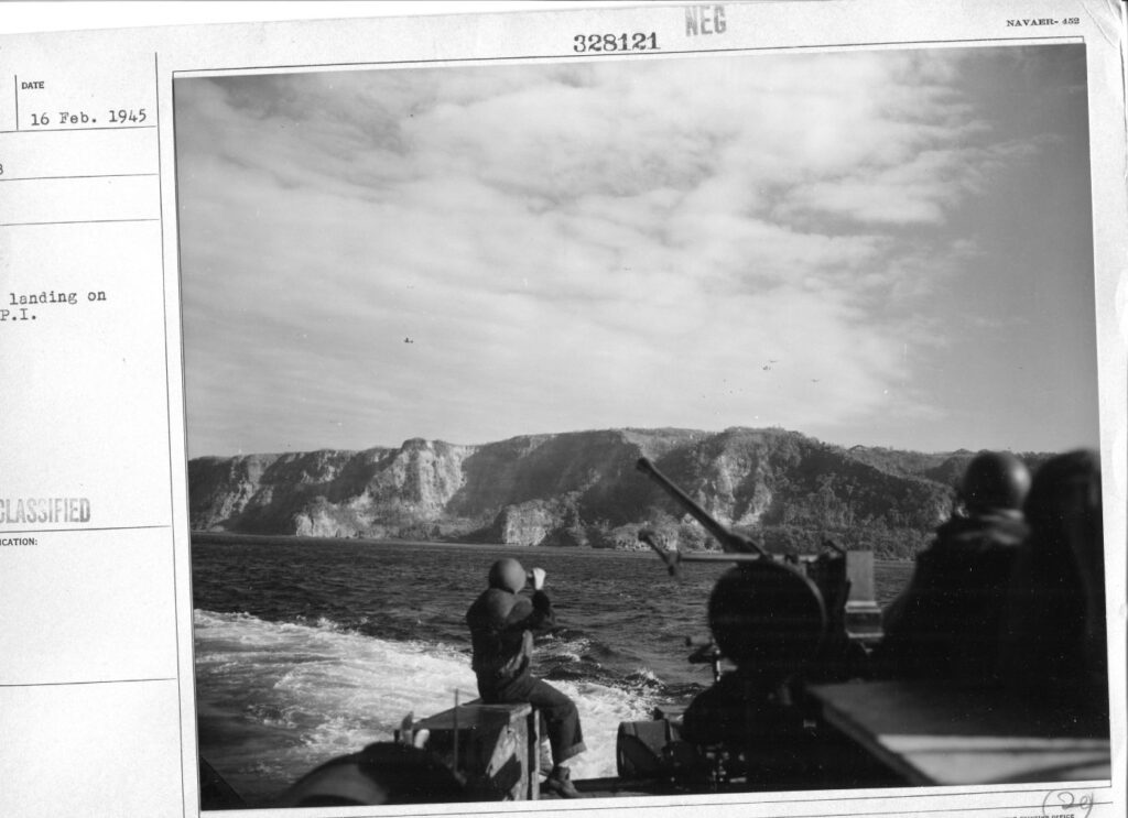
Zd248. Flickr 063. No description for this image, nor can I tell what kind of boat, craft or vessel this picture is shot from. But I’m sure as to what the image shows. The vessel is off Search Light Point at the SW corner of Corregidor Island. It must be the 16th Feb. 1945. Some paratroopers are landing short of the Landing-Zone A, the Topside Parade ground and are landing near Battery Wheeler. That area was a Japanese Hornet Nest.
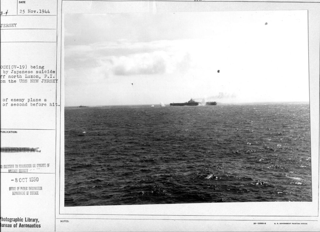
Zd249. Flickr 064. On the 25th Nov. 1944 the USS Hancock CV-19 was hit by a kamikaze plane.; photo taken from the USS New Jersey. Wikipedia says this at this URL: https://en.wikipedia.org/wiki/USS_Hancock_(CV-19)
Hancock then rejoined Rear Admiral Bogan’s Task Group with which she struck airfields and shipping in the vicinity of Manila on 29 October 1944. During operations through 19 November, her planes gave direct support to advancing Army troops and attacked Japanese shipping over a 350 mi (560 km) area. She became flagship of the Fast Carrier Task Force (TF 38) on 17 November 1944 when Admiral McCain came on board.[6]
Unfavorable weather prevented operations until 25 November, when a kamikaze roared toward Hancock, diving out of the sun. Antiaircraft fire exploded the plane some 300 ft (90 m) above the ship, but a section of its fuselage landed amidships, and a part of the wing hit the flight deck and burst into flames. Prompt and skillful teamwork quickly extinguished the blaze and prevented serious damage.[6]
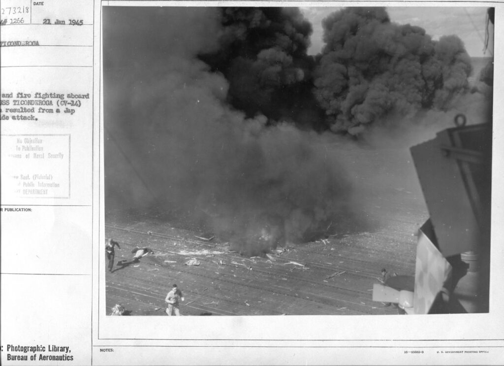
Zd250. Flickr 065. On the 21st Jan. 1945 the USS Ticonderoga CV-14 was hit several times by bombs or kamikaze planes. Wikipedia says this at this URL: https://en.wikipedia.org/wiki/USS_Ticonderoga_(CV-14)
Attacks on South Japanese islands
The three task groups of TF 38 completed their transit during the night of 20–21 January. The next morning, aided by favorable flight conditions, their aircraft hit airfields on Formosa, in the Pescadores, and at Sakishima Gunto. While it allowed American flight operations to continue through the day, it also allowed for Japanese kamikaze operations.
Just after noon, a single-engine Japanese aircraft scored a hit on Langley with a glide-bombing attack. Seconds later, a kamikaze swooped out of the clouds and plunged toward Ticonderoga. The aircraft crashed through the ship’s flight deck abreast of the No. 2 5 in (130 mm) mount, and its bomb exploded just above her hangar deck. Several aircraft stowed nearby erupted into flames and men were killed. While the crew were ordered into action to save the endangered carrier, Captain Kiefer conned his ship skillfully. First, he changed course to keep the wind from fanning the blaze. Then, he ordered magazines and other compartments flooded to prevent further explosions and to correct a 10° starboard list. Finally, he instructed the damage control party to continue flooding compartments on Ticonderoga’s port side which induced a 10° port list which dumped the fire overboard. Firefighters and aircraft handlers completed the dangerous job of dousing the flames and jettisoning burning aircraft.
Other kamikaze then assailed the carrier. Her antiaircraft gunners shot down three which all crashed into the sea, but a fourth aircraft struck the carrier’s starboard side near the island. Its bomb set more aircraft on fire, riddled her flight deck, and injured or killed another 100 sailors, with Captain Kiefer one of the wounded. Ticonderoga’s crew continued their efforts and were spared further attacks. They brought her fires completely under control not long after 1400, and Ticonderoga retired.[3]
Repair and relaunch
The stricken carrier arrived at Ulithi on 24 January but remained there only long enough to move her wounded to hospital ship Samaritan, to transfer her air group to Hancock, and to embark passengers bound for home. Ticonderoga cleared the lagoon on 28 January and headed for the U.S. The warship stopped briefly at Pearl Harbor en route to the Puget Sound Navy Yard where she arrived on 15 February. Captain William Sinton assumed command in February 1945.
Her repairs were completed on 20 April, and she cleared Puget Sound the following day for the Alameda Naval Air Station, Alameda, California. After embarking passengers and aircraft bound for Hawaii, the carrier headed for Pearl Harbor where she arrived on 1 May. The next day, Air Group 87 came on board and, for the next week, trained in preparation for the carrier’s return to combat. Ticonderoga stood out of Pearl Harbor and shaped a course for the western Pacific. En route to Ulithi, on 17 May, she launched her aircraft for what amounted to training strikes on Japanese-held Taroa in the Marshalls. On 22 May, the warship arrived in Ulithi and rejoined the Fast Carrier Task Force as an element of Rear Admiral Radford’s TG 58.4.[3]
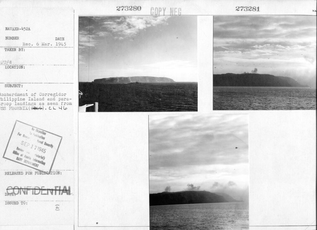
Zd251. Flickr 066. Bombardment of Corregidor Island (P.I.) and paratroop landings as seen from USS Phoenix CL-46. This was on the 16th Feb. 1945.
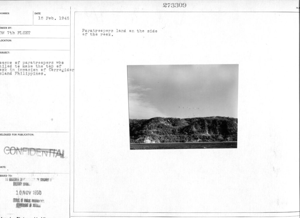
Zd252. Flickr 067. A Naval unit seems to be preparing to recue some paratroopers that landed short of their landing zone on Corregidor Island (P.I.). This seems to be the approach to Landing Zone B, the mini golf course area.
————————–
WWII, Philippines, from CDSG Friends continues, last segment 25th Oct. 2020
Friends from the Coastal Defense Study Group (cdsg.org) have given me many high-resolution pictures from NARA and other sources. I will share them here. It will be a slow project, will do it, only when I have some time.
The last 10 images. Reminder; these pictures can be downloaded in high resolution at this other album, click here:
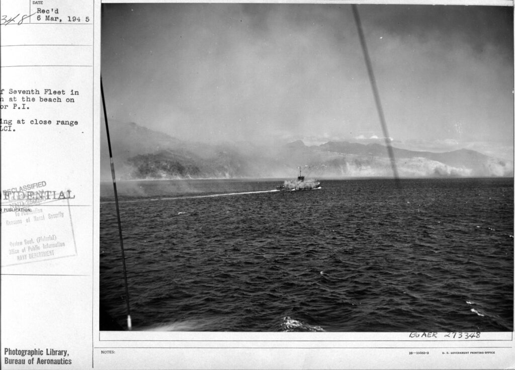
Zd261. Flickr 068. A rare picture of a Navy Landing Craft Infantry (GUN) LCI (G) at the very moment, firing off her rockets. Although the description is not clear, there is no doubt this at the assault on Corregidor in 1945. The LCI (G) is south of Corregidor, just some distance from the mouth of the Government Ravine. I recognize the Bataan Peak of Mt. Mariveles, left and the Mt. Limay Peak, right, on the other side of Corregidor. This action must have been, just before the Paratroop drop on Corregidor and the amphibious landing at the south shore, just right of this picture on the 16th Feb. 1945.
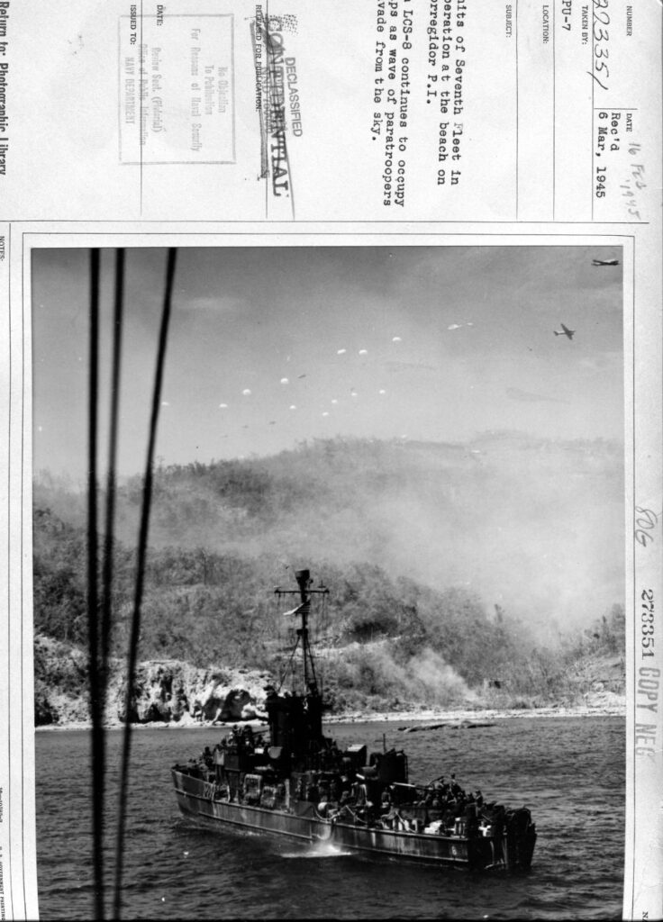
Zd262. Flickr 069. Landing Craft Support, LCS-8 at support for the assault on Corregidor Island Feb. 16th 1945. I put the ship in the vicinity, just south of the Government Ravine and Breakwater point of the former Fort Mills on Corregidor Island. Wikimedia says this about the LCS, click here:
The Landing Craft, Support (Large) were two distinct classes of amphibious warfare vessels were used by the United States Navy (USN) in Pacific and the Royal Navy in World War II. The USN versions which were later reclassified Landing Ship Support, Large also performed radar picket duty and firefighting.
The hull was the same as the Landing Craft Infantry ships. They were 158 ft 6 in (48.31 m) long, displaced 250 long tons (250 t), 23 ft 3 in (7.09 m) wide and drew 5 ft 10 in (1.78 m) when fully loaded.
During World War II, five LCS(L)(3)s were sunk in combat (see below) and 21 were damaged. Three of these small warships received Presidential Unit Citations, while six were awarded Navy Unit citations. Importantly, Lieutenant Richard M. McCool, skipper of USS LCS(L)(3) 122, was awarded the Congressional Medal of Honor.
LCS(L)(3)-7, LCS(L)(3)-26 and LCS(L)(3)-49 were sunk by suicide boats off Mariveles, Corregidor Channel, Luzon, Philippine Islands, on 16 February 1945. LCS(L)(3)-15 was sunk by kamikaze aircraft off Okinawa, Ryukyu Islands, on 22 April 1945. LCS(L)(3)-33 was sunk by shore batteries off Iwo Jima, Volcano Islands, on 19 February 1945.
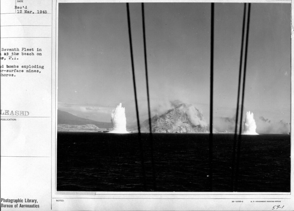
Zd263. Flickr 070. The picture description is not clear, bombs or mines. The location is south of Bottomside and Malinta Hill of Fort Mills on Corregidor Island, I recognize it clearly and for sure. It is happening on the day of the assault on the 16th Feb. 1945 or just before. I bet on bombs but if so, they missed the target by some distance.
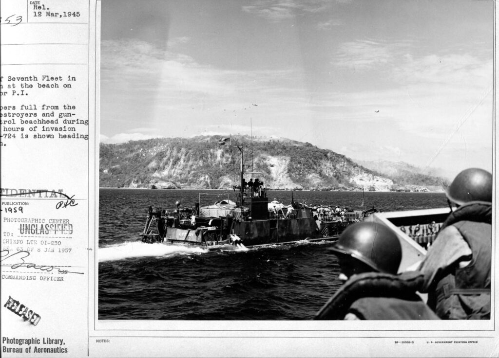
Zd264. Flickr 071. The Landing Craft Tank, LCT-724 is making its run to the south shore of Corregidor, called Black Beach for the amphibious assault on the 16th Feb. 1945. This picture seems to be shot from the Signal Bridge of a Navy 7th Fleet Warship. The location is south of the area of Battery Crockett. Paratroopers are dropping on Landing Zone B, the mini golf course at the former Fort Mills on Corregidor Island, Philippine Islands, P.I.
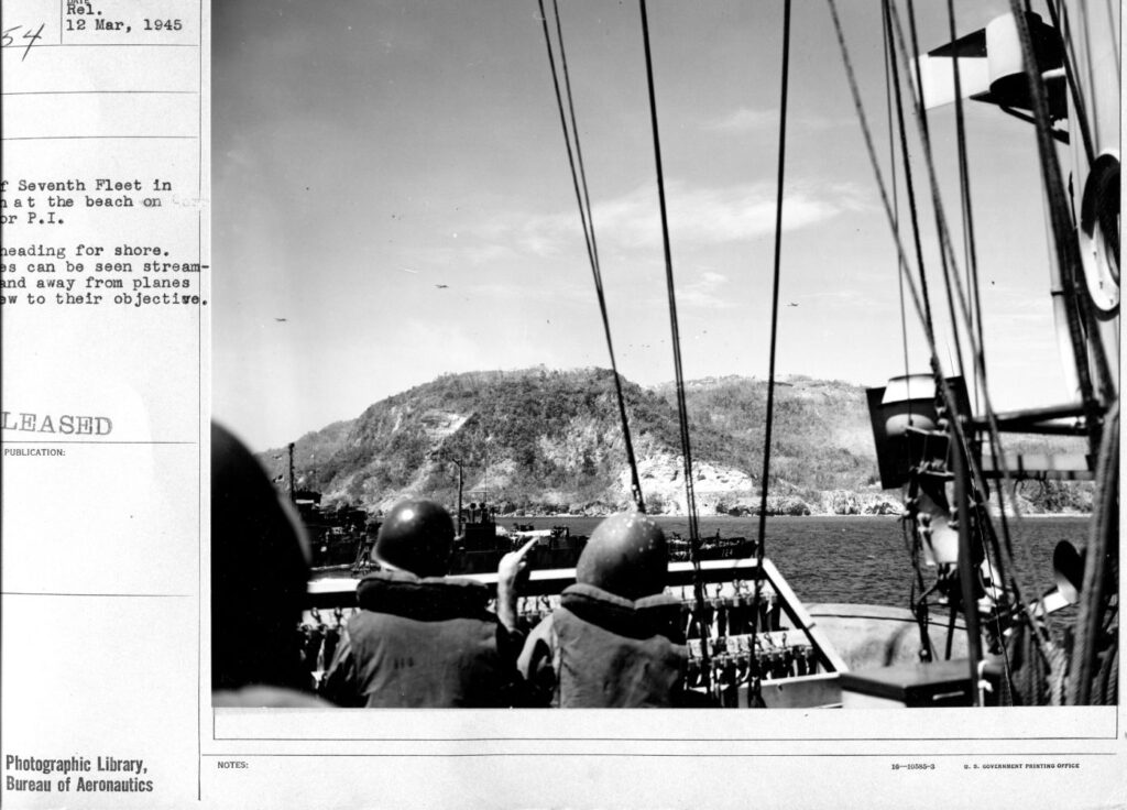
Zd265. Flickr 072. This picture is very similar as the last image Flickr 071. But the 2 vessels have advanced closer to Black Beach, Bottomside of Corregidor. I see some unique features of Topside on Corregidor Island. I see the Paratroopers, the Senior Officers Quarters, the Quarter Master ware houses. And I see a clear shot of the anti-air craft machine gun tower next to Battery Crockett.
Zd266. Flickr 073. This is a close-up of the last image Flickr 072. Well, it seems to be a close-up shot of the conning tower, LCT-724, making its run to the south shore of Corregidor, called Black Beach for the amphibious assault on the 16th Feb. 1945.
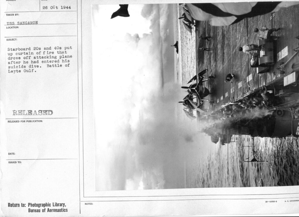
Zd267. Flickr 074. USS Sangamon (CVE-26) was an escort carrier converted from an oiler, the second ship to carry her name. The description says: 26th Oct. 1944, starboard 20s and 40s put up a curtain of fire that drove off attacking plane after he had entered his suicide dive. Battle of Leyte Gulf. Note from Karl: This ship has a long history of combat in WWII.
Zd268. Flickr 075. USS Nashville (CL-43) was a light cruiser and has an interesting WWII history, Wikipedia: Click here:
It looks like some sailors went ashore and took some pictures, perhaps they landed with Gen. MacArthur.
Nashville provided fire support and carried General of the Army Douglas MacArthur to the amphibious operations at Hollandia (present-day Jayapura), Tanahmerah Bay, and Aitape, on 22–23 April 1944.
Nashville twice more carried General MacArthur and his staff to the invasion of Morotai, Dutch East Indies in mid-September. She carried General MacArthur on his return to the Philippines, for which she sailed from Manus on 16 October. She provided fire support for the Leyte Island landings on 20 October, and she remained on station at the mouth of Leyte Gulf until 25 October, guarding the troops on the beachhead and the nearby transports.
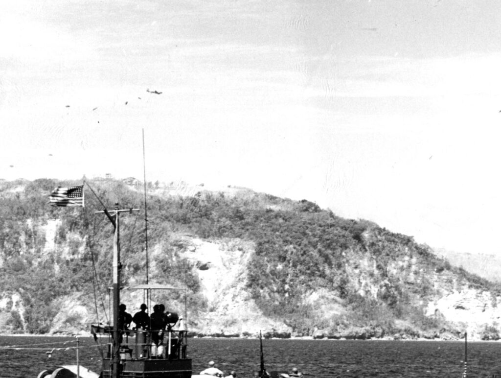
Zd269. Flickr 076. Another view of the Paratroop landing on Landing Zone B, Corregidor Island, on the 16th Feb. 1945.
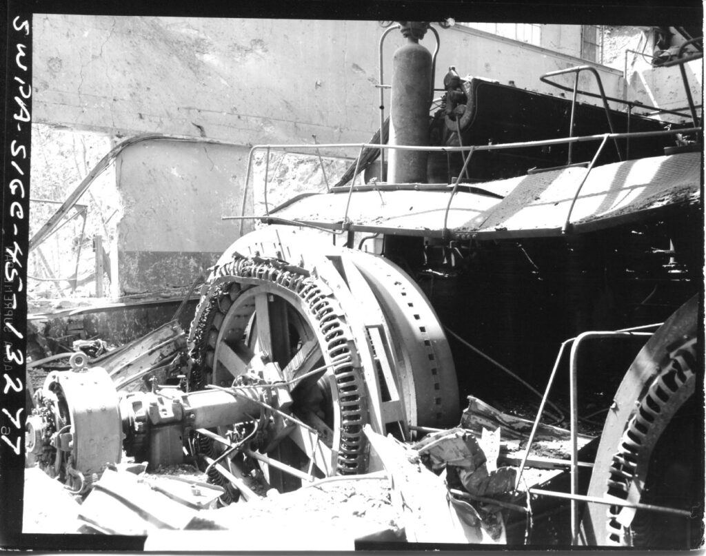
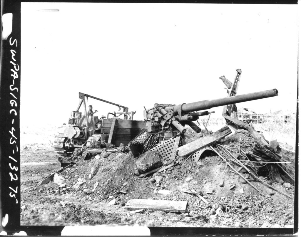
Zd270. Flickr 077. A combat debris field but the picture does not have a description. It could be on Corregidor, because it was in the folder of many Corregidor combat images. What type of gun is that? Is it a Japanese gun?