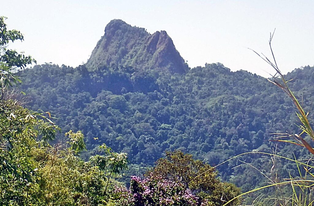
Zf164. The Rocky, Monolith Peak or Peaks of Mount Balakibok. This peak or these peaks are prominent visible from just about anywhere in Olongapo. The Kalaklan Ridge leads to the peaks and a road and power lines to the Dizon Mine run along the ridge. The power lines are gone now and the road is now impassible at the upper end. My friend Carlito Pickering said, when he was stationed here in the 1980s he drove along this road, passed the peak to its left and then descended to the Dizon Mine Pass about 1 km or so. I walked this trail to about 10 years ago and 5 years ago when I tried it again I lost the trail, it was completely overgrown.
——————————–
The roads, tracks to the Dizon Mine from the in Subic Town and the Kalaklan Ridge road from Olongapo were once useable but are now grown over. Friends and I considered this a long and challenging trail and used it several times until about 10 years ago.
A lot of people are surprised that this large gold and copper mine existed just over the hills behind Olongapo. The normal route of communication from and to the mine was via the Mapanuepe River Valley, thru the San Marcelino area and to the Dizon Port located at the end of Baloy Beach in Olongapo.
The heavy rain in 1997 shut down the Dizon Mine, the open pit terraces collapsed and buried the open pit dewatering equipment, facilities. The mine was also severally affected by Mount Pinatubo in the early 1990s. The Marella River which comes from Mt. Pinatubo blocked the Mapanuepe River Valley exit and so a large lake formed. This new Mapanuepe Lake buried several communities in the Mapanuepe Valley, including Dizon Mine facilities. The Dizon Mine operator built a new road on the south slopes of the Mapanuepe Valley which is still used today!
Just this year I made it my goal to find the Dizon Pass again. I tried it 2 weeks ago and I failed. On the 25th of May 2021 I tried again, with new calculation based on the previous try, and succeeded. So, I’m happy that archived it, it was challenging. I like to share this walk, hike.
——————————————-
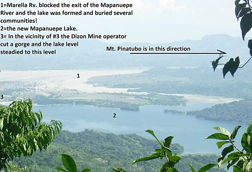
Zf165. After I reached the pass, I followed a trail up the ridge to the left and followed the road down to the Dizon Mine but it was so grown over that I could not go further without a bolo or machete. Only once was I able to get a glance of the Dizon Mine, Mapanuepe Lake and the Marella River Mt. Pinatubo Lahar area, this is one of those shots.
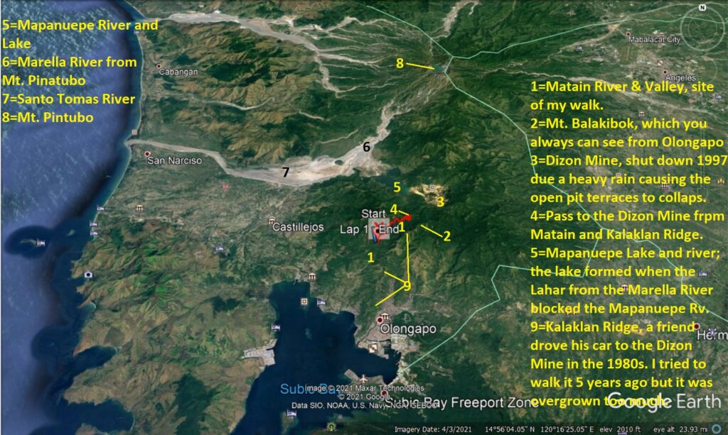
Zf166. This Google Earth image gives the big picture how my walk and views relate to the bigger geographic area. I think pictures without subscriptions are not very interesting most of the time.
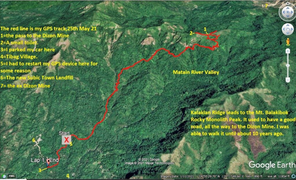
Zf167. My track in the Matain River Valley to the Dizon Mine Pass zoomed in. In the valley the trail was a pretty good trail, easy to follow. But near my goal the tracks became many and were confusing. There was much animal activity (tracks or disturbed soil, grounds) on top, under the pass but on this side only. And the former road had completely disappeared.
About 1994 the Dizon Family built a new road at along the track I walked today. They wanted an alternat5e road to their mine. But the Benguet Corporation never used it and it is pretty much grown over now.
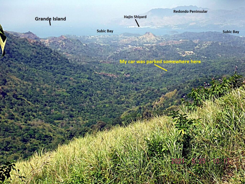
Zf168. A view down-river the Matain River Valley and we have the grand Subic Bay Vista. On this side, several times, did I have this view or the Kalaklan Ridge across the valley.
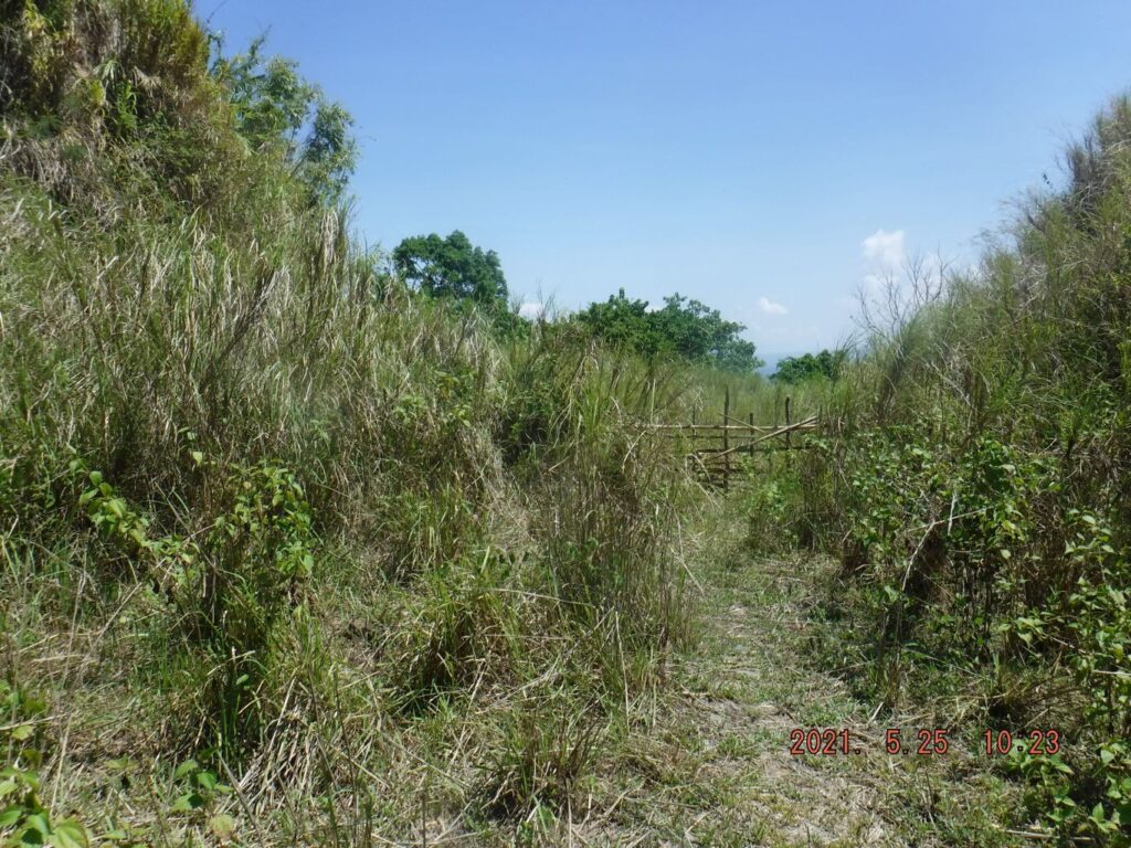
Zf169. This is the actual Dizon Mine Pass, looking toward the mine direction. The Dizon Mine road veers immediately to the right and runs down just parallel under the ridge line, on the Dizon Mine side.
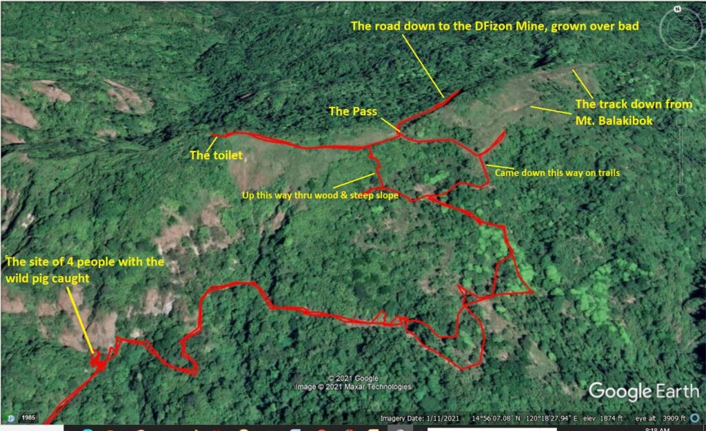
Zf170. This is the Dizon Mine Pass area zoomed in. I remembered a road that went up the ridge to the left and that was the trail I first came across and I followed it up. It did have an end and there was a small toilet. I assume it was used as a lookout point during the 1990s Lahar Crisis.
In this picture, I share with you, is where I came across a party of 4 men who just killed a wild female big that was caught in a trap set the day before. On my way back they had it roasted. I asked them whether I could take a picture and they said no!
The old road that connected to the pass, I did not find anymore and so I decided I got to go straight up, wherever I could go thru and hang on to trees or scrub. Well, I did come across the old road, now a trail to the lookout and toilet station. From that point it was easy just follow the trail and that is how I came down and meet up with my track coming up.
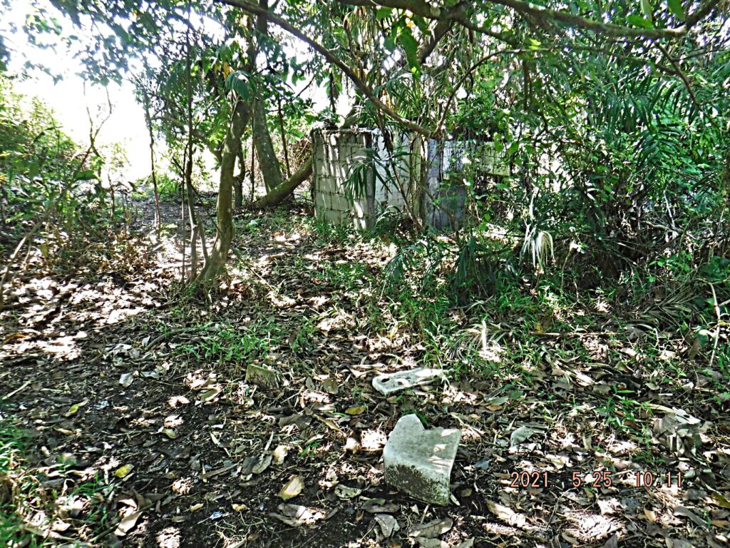
Zf171. Here is the toilet station, the throne lying outside, though. I assume it was used in the early 90s as an observation point to watch for the Mt. Pinatubo Lahar rushing down the Marella River.
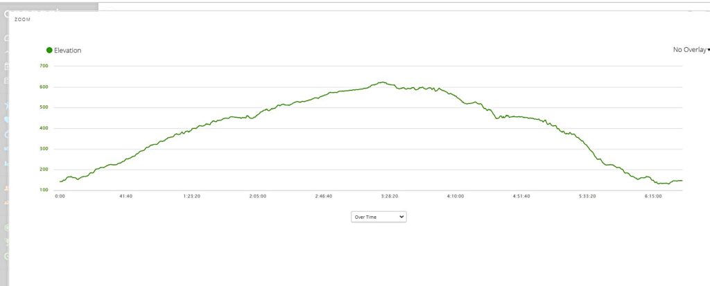
Zf172. Total elevation gain for this walk, hike was 527 meter, not bad for this 79 year young stud and it is hot here, especially this month!